Posts Tagged ‘beach’
walk on the shore

~
ignition
Sea-rocket (Cakile edentula Hook.)
~
clumps of Sea-rocket
are splashes of lime on sand
missiles from lavender flowers
~
pepper to tongue
pungent breath of Cakile
cardamom and caraway
~
flavour our laughter
giggles of gulls cross sober sand
intervention in sluggish lives
~
launches from Cape Canaveral
moon-walking on the beach
splash-downs in Sargasso Seas
~
most days are moth-eaten –
paper cuts, missives, e-mails to answer
problems, resolutions without teeth
~
the seawind smooths its sand
begs for someone to take a stick
scratch out a love song
~
~

~
Copyright 2015 Jane Tims
ordinary magic

~
ordinary magic
~
small blue jar
emptied of face cream
reveals a false bottom when held to the light
a bright inverted inner shell
hovers untouchable
~
the peel of an orange
spurts flammable oil
cantrips of fire
~
press a shell to your ear
murmur of ocean
~
~
Copyright 2015 Jane Tims
islands and gorges (day 13 and 14)
My virtual bike ride continues with a ride from Blackland to Belledune …
~
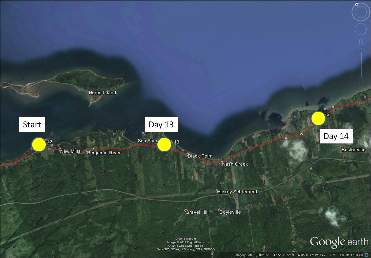
distance travelled (map from Google Earth)
~
8-13 February 5, 2014 20 minutes 3.0 km (Blackland to Sea Side)
8-14 February 8, 2014 35 minutes 7.0 km (Sea Side to west of Belledune)
~
As I have said, I have often visited the area I am ‘biking’ through as part of my past work. In the 1970s and 1980s, we visited many sites in the area to measure the levels of air pollutants in local lichens. We collected lichens of the genus Cladina (reindeer lichens) since they absorb all of their nutrition from the air and air pollutants accumulate in their tissues …
~

species of the lichen ‘Cladina’ grow in tufts on high elevation, rocky areas and in low-lying bogs
~
One of our sampling locations was Heron Island, an island 3.5 km long, lying just off the coast …
~
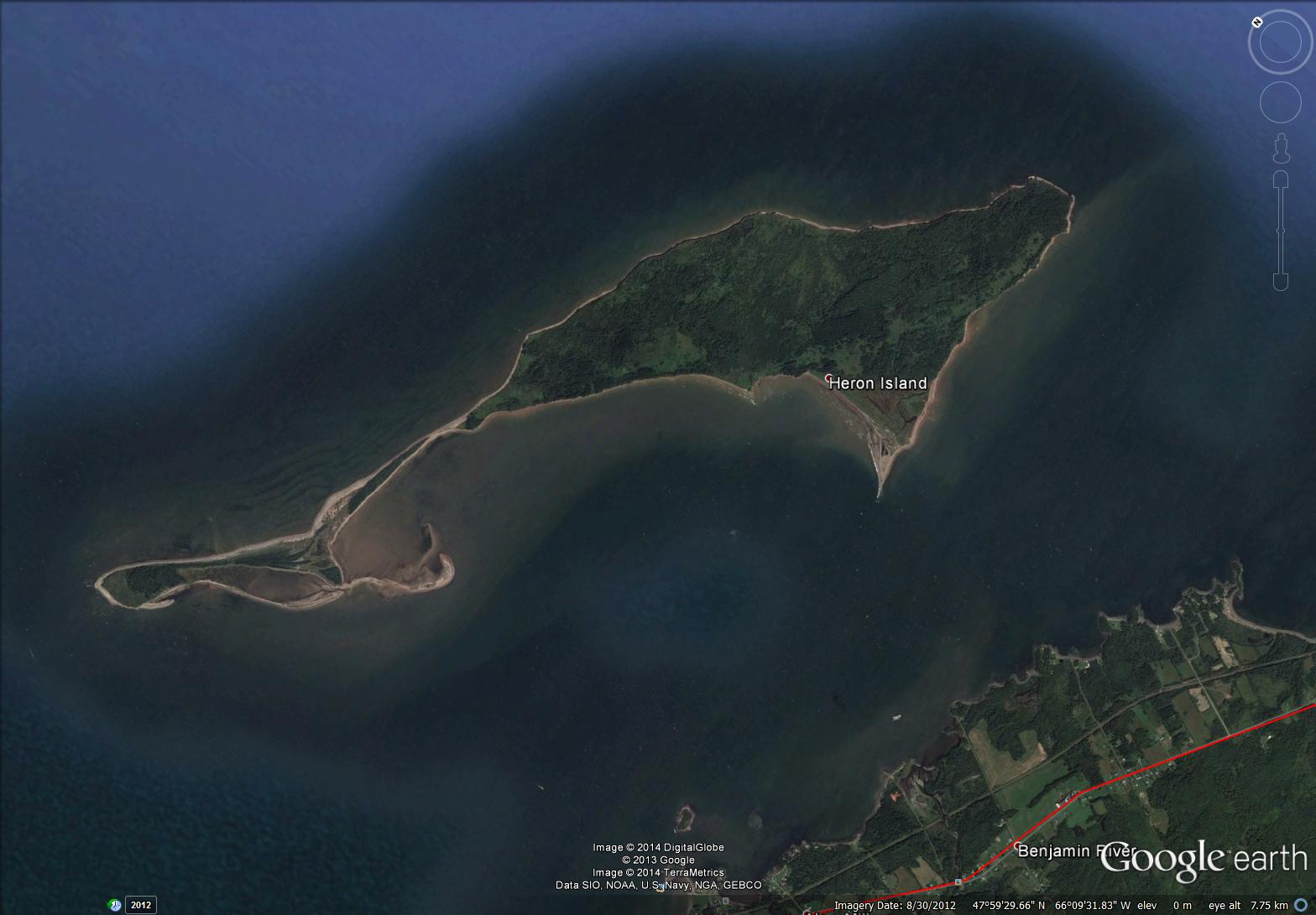
satellite image of Heron Island (map from Google Earth)
~
I have been on the island several times … it was a good place to collect lichens since there are not many local emissions to contaminate the sample (no cars, dusty roads, and so on).
~
The island is a landscape of low-lying salt marsh and beach as well as forested and grown-over old-field areas. On the boat on the way to the island, I remember watching scallop fishermen working on their barges in the shallow waters. Although people have lived on the island as recently as 1940, the island is now protected and co-managed by the provincial government and First Nations peoples who have traditionally used the island as a summer residence.
~
Today’s painting is of a rather stormy day along the bay shore just east of Heron Island …
~

February 11, 2014 ‘Baie des Chaleurs’ Jane Tims
~
Also in the area where I was ‘biking’ is the very hilly landscape of the Jacquet River. The high elevation plateau has been deeply eroded by the Jacquet River – the river and its tributaries flow through deep gorges. The 26,000 hectare ‘Jacquet River Gorge’ is one of New Brunswick’s Protected Natural Areas. Reaching the locations of our lichen collections took us deep into the area and I remember how steep the hills (and the roads) were as we went to our collection sites.
~

February 17, 2014 ‘lower Jacquet River’ Jane Tims
~
Copyright 2014 Jane Tims
return to the shore (day 54 and 55)
For a few days of my virtual travel along the Cornwall coast, I haven’t been seeing much of the coast. This is because my route took me inland, to skirt the tributaries of the Helford River. Now, though, I am travelling along the coast again.
~

map showing distance travelled (map from Google Earth)
~
7-54 December 4, 2013 35 minutes 3.0 km (from Porthoustock to St. Keverne)
~
This is the famous Lizard Coast, called, not for the serpentine rock in the area, or for any reptile, but after the Cornish word meaning ‘high court’ (Lys Ardh). I have seen a few references to the Lizard, including this sign in St. Keverne …

sign showing a lizard in St. Keverne (image from Street View)
~
7-55 December 6, 2013 35 minutes 3.0 km (from St. Keverne to Coverack)
~
I haven’t attempted many people in my paintings, but in the watercolour below, I tried to capture a couple of the many people I saw enjoying the walk along the coastal road in Coverack. With artists’ licence, I paired two people who in real-life have likely never met one another !!!!
~

December 10, 2013 ‘walking in Coverack’ Jane Tims
~
Copyright 2013 Jane Tims
California #3 – the Pacific Ocean
When I went to California, I wanted to do four things: see my brother and my sister-in-law in their new home, drive over the Golden Gate Bridge, see Star Trek Academy (or its eventual location) and stick my toe in the Pacific Ocean. The first three were easy, but seeing the Pacific and touching it were two different things. We saw it almost immediately from the plane. Then we walked along Fishermen’s Wharf, watched the boats bobbing in the quay, walked among the Bay fish at the Aquarium and travelled on the Bay Cruise around Alcatraz and under the Golden Gate Bridge twice. Beyond the Golden Gate Bridge, I experienced some of the power of the Pacific Ocean. As you cross under the Bridge, the water turns very choppy and churns and twists and swells.
~
Once we got to Calistoga, my brother gave us his car for the day and my son and I headed across the winding roads of the Calistoga hills. Thanks to our GPS and my son’s piloting skills, we reached the coast with little problem. The waves were gorgeous – big white breakers on a blue ocean and a blue sky in the background. Surfers were riding the biggest of the waves. However, we couldn’t seem to find a way down to the beach that wouldn’t wreck my knees, so we contented ourselves with the view. Then we ate at the ‘Tides’ restaurant, at a seat near the window directly over the water. It was so close we both felt as though we were moving!
~
Our last stop was at Goat Rock. After a snail’s pace and a harrowing descent of very twisty roads, we reached the beach, but after reading the signs (they said it is the most dangerous beach in California for undertows), we decided to content ourselves with walking in the deep sand. As we turned from the ocean to return to Calistoga, I wondered why I was not disappointed at not getting my feet wet. The answer … I intend to return again and I’ll poke my toes in then!!!!
~
Since my son has all our photos, I will share some photos and my painting of the Atlantic Ocean (Lawrencetown Beach) from my visit this spring with my other brother.
~

~


~

~

November 16, 2013 ‘Lawrencetown Beach, Nova Scotia’ Jane Tims
~
~
Copyright 2013 Jane Tims
on the beach at Millendreath 7-8
~

church at St. Martin (image from Street View)
~
~

map showing distance travelled (map from Google Maps)
~
On Day 8 of my virtual bike trip along the coast of Cornwall, I did three watercolors of the countryside. I can’t keep this up, but for now, I am enjoying learning about watercolor technique. My plan is to practice, using the scenes of Cornwall as my inspiration, and later, do a series of watercolors ‘en plein air‘ in an area of New Brunswick I know well.
~
I began my biking in Millendreath on the beach looking toward Looe Island. I love the band of red seaweed, left by the waves at high tide. My waves need work – I have tried leaving white space and then highlighting the areas later with Titanium White, but this does not allow for splashy detail in the waves. I plan to try a product called ‘resist’ – it keeps small areas free of paint until it is removed. The name Millendreath sounds like it comes straight from the Lord of the Rings …
~

July 13, 2013 ‘beach at Millendreath’ Jane Tims
~
In St. Martin, I passed by the Parish church …
~

July 13, 2013 ‘Parish Church, St. Martin’ Jane Tims
~
On the high land above Millendreath, the scenes are of distant hills and fields …
~

July 13, 2013 ‘countryside near St. Martin’ Jane Tims
~
Copyright 2013 Jane Tims
side roads 6-9
~

vines on a wall near La Prises (image from Street View)
~

~

map showing distance travelled (map from Google Earth)
~
Any time we go for a drive in the countryside, I always wonder where the side roads lead. It is the same on my virtual bike trip in France. One of the limitations of virtual travel is that I cannot just get off my bike and walk down an interesting side road.
Sometimes Street View gives a very good idea of what I would find if I walked down one of those roads. Perhaps a mansion and beautifully kept grounds …
~

beautiful grounds (image from Street View)
~
Sometimes the way is mysterious and I can only imagine what must lie beyond the view …
~

two side roads, side by side (image from Street View)
~
Sometimes there is just a glimpse of a yard or a house …
~

I wonder what lies beyond the white gate (image from Street View)
~
Sometimes I know that beyond my view is a broad beach of white sand and the sound of the ocean …
~

access to the sea near La Passe (image from Street View)
~
Best View: side road behind a white gate …
~

June 13, 2013 ‘road beyond the gate’ Jane Tims
~
Copyright Jane Tims 2013
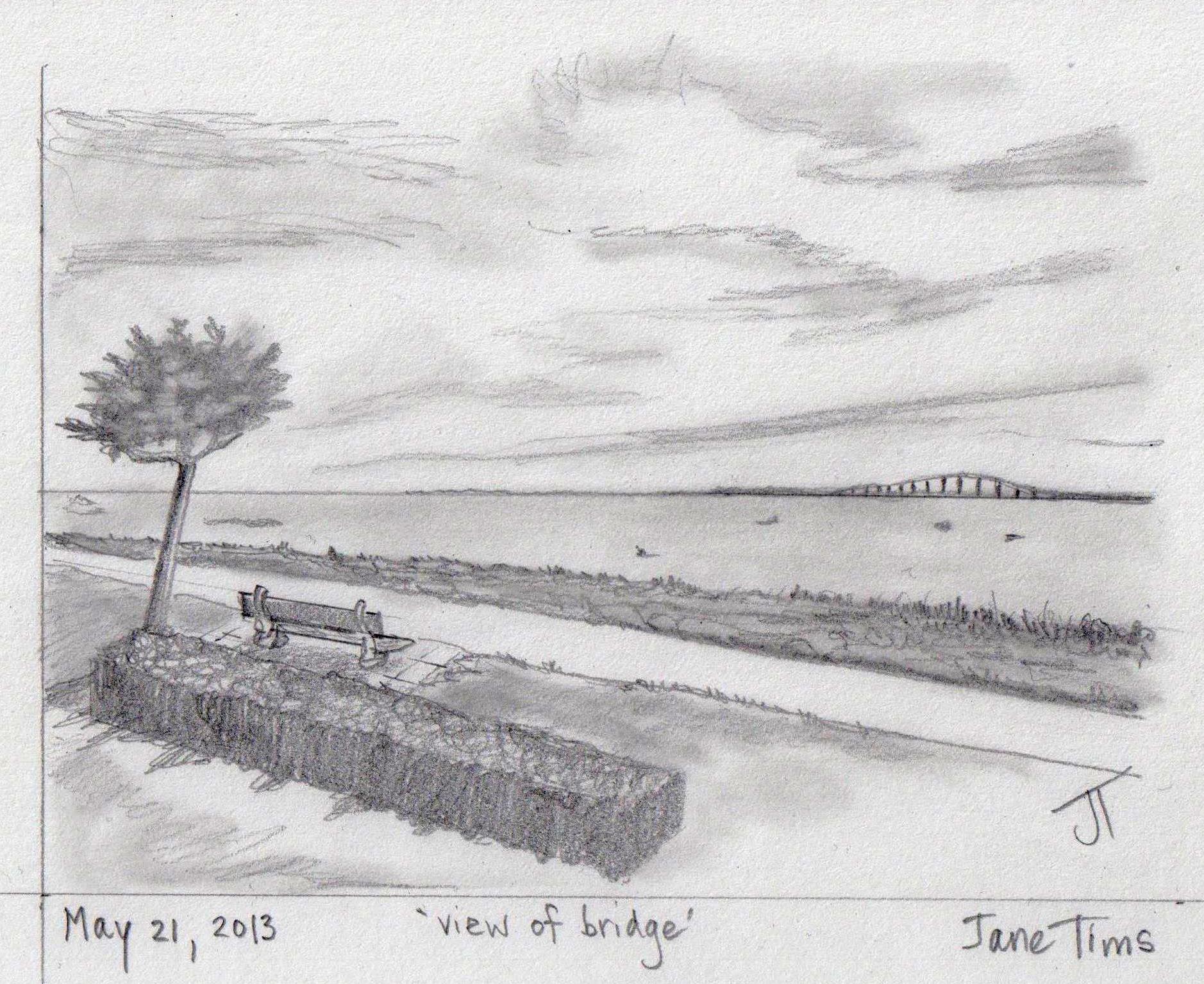
looking out to sea 6-4
~

view from Ile de Ré with the bridge in the distance (image from Street View)
~

~

map showing distance travelled (map from Google Earth)
~
I am enjoying my glimpse into the way of life on Ile de Ré. The houses include the now-familiar two-story dwellings on narrow streets. Most of the houses have painted shutters …
~

narrow street in Rivedoux-Plage (image from Street View)
~
I also see more modern houses tucked away behind fences and walls …
~

street on Ile de Ré (image from Street View)
~
Where the route runs along the ocean, there are pleasant walkways and marinas for boaters …
~

houses along Rivedoux-Plage (image from Street View)
~
There are lots of places to sit and watch the ocean. Some views overlook extensive oyster farms in the zone of the low tide …
~

~
A closer look at my route map shows the rectangular oyster-growing areas just off-shore …
~

~
Best View: view across the Bay of Biscay toward the Ile de Ré Bridge – a place to sit and watch the ocean …
~
~
Copyright Jane Tims 2013
Sea-rocket (Cakile edentula Hook.)
Sea-rocket, also known as Seaside Mustard and caquillier in French, is found on sandy or gravelly beaches along the coast.

Cakile is a sprawling plant with succulent, branched stems. The leaves are thick and fleshy, with blunt-toothed margins. The four-petalled flowers are small, purple and located at the tip of the stem.

The name Sea-rocket comes from the distinctive shape of the seed pods. These have a narrow base and a pear-shaped tip, like a rocket. Cakile is an old Arabic name and edentula means ‘without teeth’.
Sea-rocket is edible. It has a hot, pungent taste, similar to radish. The stems, leaves and pods can be added to salads or boiled for 5 to 10 minutes to give a milder taste.
~
~
Cakile wind
~
the beach sizzles today
the breeze a peppered wind
the sand Cakile-hot
~
wind scours the shore-bands
of seaweed – rockweed, kelp
bleaches them, crisped and dry
~
sand dries, adheres to skin
brushes away, a rub
a sandpaper polish
~
the tongue too hot for words
the seas too salt for tears
tans ruined, scorched and red
~
~
© Jane Tims 2012

~
Warning:
1. never eat any plant if you are not absolutely certain of the identification; 2. never eat any plant if you have personal sensitivities, including allergies, to certain plants or their derivatives; 3. never eat any plant unless you have checked several sources to verify the edibility of the plant.returning to the shore
Each summer we try to include a visit to the seashore in our vacation plans. This year we explored the coast of Maine and discovered Acadia National Park. Last year, we followed the South Shore of Nova Scotia, stopping at its many public beaches and byways.
The seashore is a magical place. One of the beaches we visited in 2010 was Crescent Beach, near Lunenburg. At the far end of the two kilometre long beach was an outcrop of calcareous rock. This rock had been eroded and pitted by wave action over the millennia. At one spot, the erosion had worn a small hole in the rock, just big enough to put my finger through. For that moment, I was wearing the whole earth as a ring on my finger!!

wearing the world on my finger!
The other magical aspect of the seashore is its changeability. In 2009, we followed the Eastern Shore of Nova Scotia and made our second visit to Tor Bay, near Larry’s River. When you stand on the beach at Tor Bay, the energy of the ocean and the drama of the wave action occupies all of your senses, all of ‘self’. The drama had also changed the beachscape significantly between our two visits, shortening its depth and exposing rocks I had not seen on our first visit.

It was as though we were not in the same place at all, but remembering a fable about a beach we had once known. No matter how hard we tried, we could never return to the same beach we had visited before.
fable
~
1.
~
stone
eroded
~
the fragments
layered by water
forged by fire
thrust and folded
into
stone
~
2.
~
this morning
the moon is real
sculpted in wavefoam
smooth as a pebble
random in the clatter
~
real
not a fable of moon
~
the rocks are folded
half-buried in sand
~
on the shore
an igneous man
in his lap a puddle of water
salt crystals
and stars
~
a quartz river
seams his forehead
~
real
not a fable of river
~
3.
~
I place quartz stones
too heavy for the gulls
to gather
~
these stones will shine
in darkness
a long line leading home
~
4.
~
I choose small stones
with smooth and shine
~
stones like eggshell
or potatoes pushed
into ground
~
pearl buttons
turned by a clumsy hand
rice pelting the window
lanterns shining in the dark
~
5.
~
at midnight
I run to the shore
the white pebbles
gather me to the moonlight
a dotted line
on the asphalt road
~
6.
~
the pebbles do not
wait for me
they fade
and scatter
roll over and over
lost
among so many
common stones
~
the wave edge
unravels behind me
~
7.
~
the path home is a fable
not real
~
in my lap is a pool
salt water
and stars
~
© Jane Tims 1998

Crescent Beach near Lunenburg, Nova Scotia


