Archive for August 2013
seasonal shifts 7-18
~

treed roadways near Carlyon Bay (image from Street View)
~

~

map showing distance travelled (map from Google Earth)
~
On my virtual tour of the residential area of Carlyon Bay, I encountered another of the seasonal shifts I have noticed before in Street View. One minute, I am in the month of May and the hydrangea are unremarkable green shrubs …
~

hydrangea in May (image from Street View)
~
and the next minute I am in August, and the hydrangea are in full bloom …
~

hydrangea in August (image from Street View)
~
Hydrangeas are like natural litmus paper … the color of the blue-tinted flowers is determined by the acidity of the soil. Lower pH soils (less than 6) tend to produce blue flowers. Higher pH soils (greater than 6) produce pink flowers.
~
Best View: hydrangea in magnificent bloom, Carylon Bay …
~

August 10, 2013 ‘hydrangeas, Carlyon Bay’ Jane Tims
~
Copyright 2013 Jane Tims
technology and industry along the road 7-17
~
My virtual biking has taken a turn for the better. As a reward to myself for keeping at my biking for 6 months (!), I splurged on an I-Pad. My son set up wireless in our house and now I can go to my stationary cycle and use Street View directly. I am using an app called MobiMaps (Brainflash).
Previously, I spent hours downloading images from Street View and transporting them physically on a flash drive to my small computer. Using the I-Pad is a great time saver. The I-Pad has also given me the ability to look around the countryside more, so I am biking longer (35 to 50 minutes per session compared to the 30 minutes I was doing). My goal now is to work up to the recommended 150 minutes per week of exercise.
~

~

map showing distance travelled (map from Google Earth)
~
Today’s journey was not particularly photogenic. The area between Par and Carlyon Bay is very industrial. I saw lots of evidence of abandoned industrial buildings …
~

abandoned chimney with vines (image from Street View)
~
One of the abandoned chimneys had a tree growing from the flue opening!
~

abandoned industrial space (image from Street View)
~
The road also followed the train track and I was treated to the view of a high-speed train going by …
~

a passing train (image from Street View)
~
Best View: an abandoned industrial building near Carlyon Bay … not very pretty, but it gave me a chance to practice a different approach to ‘sky’. The bush of Gorse did not turn out so well, but I like the vine-covered roof of the building and the vine-covered chimney …
~

Aug 9, 2013 ‘abandoned industry, Carlyon Bay’ Jane Tims
~
Copyright 2013 Jane Tims
historic hills 7-16
On the 17th day of my virtual bike trip along the Cornwall coast, I enjoyed a long trip down Polmear Hill near Par. I also learned about the Rashleigh family who built the mansion of Menabilly, the inspiration for Manderley, the house in my favorite book, Daphne du Maurier’s Rebecca.
~

~

Map showing distance travelled (map from Google Earth)
~
On my way down Polmear Hill, I spotted this Celtic Cross by the road. Some research told me this stone commemorates a carriage accident on Polmear Hill …
~

stone cross on Polmear Hill (image from Street View)
~
At the bottom of the hill was an interesting group of connected houses, the Rashleigh Almshouses. Jonathan Rashleigh (1591-1675), a merchant and politician, had these built in 1653 to provide a home for poor widows in the area …
~

Rashleigh Almshouses – the small units once housed poor women from the community – today, groups of two units have been joined to make private residences (image from Street View)
~
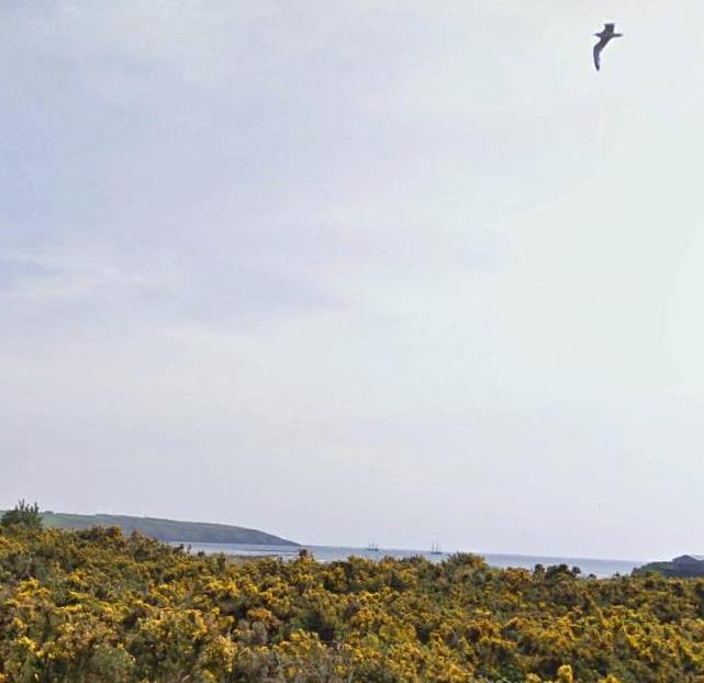
Near the end of my bike trip I saw two tall ships out in St. Austell Bay …
~
~
Best View: a hut on Polmear Hill … since it is near a bus stop and at the end of a paved footpath, I wonder if this is an old abandoned hut, or if it was built or repurposed for a bus stop shelter…
~

August 2, 2013 ‘hut on Polmear Hill’ Jane Tims
~
Copyright 2013 Jane Tims
legends along the road 7-15
Biking (virtually using Street View) through Cornwall is proving to be an adventure. I am seeing interesting houses, encountering magical byways and learning a lot of history. Today I drove through the town of Fowey, famous for its associations with Daphne du Maurier, one of my favorite authors.
~

view of Polruan from Fowey (image from Street View)
~

~

map showing distance travelled (map from Google Earth)
~
Fowey is a place of grand estates and mansions …
~

mansion in Fowey (image from Street View)
~
and colorful houses …
~

colorful houses in Fowey (image from Street View)
~
Beside the road outside of Fowey is a granite pillar known as The Longstone or the Tristan Stone. This may be the burial place of the archetype of Tristan, of the legend of Tristan and Isolde. The legend tells the tragic story of a Cornish knight and an Irish princess who fall in love after ingesting a potion …
~

Tristan Stone by road west of Fowey (image from Street View)
~
I also took a quick side trip to an interesting place on the map, just north of Fowey. From the road, Castle Dore appears as an irregularity in the landscape. It is the grass-covered ruin of a ‘hill fort’ of the Iron Age, occupied first during the 4th to 1st century B.C. ! The fort protected people from Roman invaders …
~

Castle Dore from road (image from Street View)
~
The fort was also occupied during the Dark Ages. In legend, it is identified as the hall of King Mark (who Isolde was supposed to marry) and is therefore associated with the legend of Tristan and Isolde …
~

aerial view of Castle Dore (map from Google Maps)
~
Best View: New Road Hill in Fowey, a ‘sunken’ roadway with a staircase for pedestrians …
~

July 28, 2013 ‘Fowey roadway’ Jane Tims
~
Copyright 2013 Jane Tims
encounters with literature 7-14
~

coast near Fowey (image from Street View)
~

~

map showing distance travelled … Daphne du Maurier’s house is near the yellow dot at about eight o’clock … Pont Pill is the stream at about one o’clock (map from Google Earth)
~
On today’s virtual bike trip, I happened upon two locations famous for their literary connections. Near the end of my trip, I saw Readymoney (from the word for pebbly), the house Daphne du Maurier lived in during 1942. She lived here while writing her book Hungry Hill ( Doubleday-Doran, 1943) …
~

~
Across the road is the beach at Readymoney Cove. I imagine Daphne du Maurier looking out on this view as she wrote or thought about her writing …
~

Readymoney Cove in Fowey, across from du Maurier house (image from Street View)
~
The house was originally the coach house for the mansion at Point Neptune …
~

~
I also took a side road to Pont Pill. Pont Pill or Pont Creek is thought to have been the inspiration for Kenneth Grahame’s Wind in the Willows …
~

Pont Creek beside a nicely landscaped house at Pont Pill (image from Street View)
~
Best Views: Little Lantic Beach and the old water mill on Pont Pill …
~

July 23, 2013 ‘Little Lantic Beach’ Jane Tims
~

July 29, 2013 ‘old water mill at Pont Pill’ Jane Tims
~
Copyright 2013 Jane Tims
water and stone 7-13
~

treed archway over road near Lansallos (image from Street View)
~

~

map showing distance travelled (map from Google Earth)
~
After seeing hidden doors and arched roadways, I am on the lookout for other evidence of enchantment on my Cornwall journey. So, when the road dipped into one of those treed valleys …
~

treed archway near Lansallos (image from Street View)
~
I was not surprised to see an unexpected stone stairway …
~

unexpected stairway (image from Street View)
~
and a roadside fountain …
~

water ‘fountain’ in roadway west of Lansallos (image from Street View)
~
I think this is a way of making the water in a hillside stream more accessible, but it made me think of the magical associations of woodland pools …
~

July 25, 2013 ‘reflection’ Jane Tims
~
Best View: a stone house near Lansallos … pen and watercolor …
~

July 22, 2013 ‘stone house near Lansallos’ Jane Tims
~
Copyright 2013 Jane Tims
old trees and old towns 7-12
~

hedgerows along Raphael Road (image from Street View)
~

~

map showing distance travelled (map from Google Earth)
~
After the picturesque town of Polperro, the road I am following takes an inland route. I peer over the hedgerows and watch for other vehicles on the narrow road …
~

be prepared to give way!!! (image from Street View)
~
Near Lansallos, agricultural land spreads endless, to the very edge of the sea cliffs. There are sheep in the pastures … I just leave little unpainted gaps in the watercolor!
~

July 20, 2013 ‘fields along coast near Lansallos’ Jane Tims
~
~
Lansallos is a charming village with places to stay …
~

Rose Cottage, Lansallos (image from Street View)
~
white houses, white blossoms …
~

white house, white flowers and white cars (image from Street View)
~
and an old (15th century) church …
~

St. Ildierna Church, Lansallos (image from Street View)
~
You can see the tower of St. Ildierna church from miles away. The interior of the church was partly destroyed by fire in 2005 but has since been restored through donations.
~
The village of Lansallos is listed in the Doomsday Book (the landowner survey done for William I and completed in 1086) as the Manor of Lansalhas !!!
~
Best View: old tree near Lansallos … ink and watercolor …
~

July 20, 2013 ‘old tree near Lansallos’ Jane Tims
~
Copyright 2013 Jane Tims
narrow streets and wide-open countryside 7-11
~

Landaviddy Lane in Polperro (image from Street View)
~

~

map showing distance travelled (map from Google Earth)
~
I have never encountered such narrow streets as in Polperro. In this charming little town, the streets bulge with sightseers. The narrow streets can be confusing, so it’s a good thing the roads are labelled to show the ‘Way Out’ …
~

July 21, 2013 ‘way out in Polperro’ Jane Tims
~
Best View: countryside near Polperro … yellows are a little bright in the scanned version compared to the original painting …
~

July 19, 2013 ‘countryside near Polperro’ Jane Tims
~
Copyright 2013 Jane Tims
peering over hedgerows 7- 10
~

Talland Bay (image from Street View)
~

~

map showing distance travelled (map from Google Earth)
~
I am beginning to realise, the Cornwall countryside is often not visible from the road, a result of the ubiquitous ‘hedgerow’ …
~

peering over hedgerows (image from Street View)
~
Fortunately, there are weird trees at intervals …
~

eerie tree near Talland (image from Street View)
~
and places where the trees make tunnels of the road …
~

narrow road and natural archway (image from Street View)
~

natural archway (image from Street View)
~
Best View: Church in Talland … I tried using pen with the watercolour … I love the big cloud … but the gravestones a bit thin and wavy …
~

July 18, 2013 ‘church in Talland’ Jane Tims
~
and the waves at Talland Bay … these waves have some frothiness compared to my painting of the beach at Millendreath (see post for August 7, 2013) …
~

July 19, 2013 ‘waves at Talland Bay’ Jane Tims
~
Copyright 2013 Jane Tims
hills and harbours 7-9
One advantage of a virtual cycling trip – a day like today is not exhausting in spite of steep roads. Visiting the city of Looe involves biking from the higher land around St. Martin, down into the valley where Looe is situated. Leaving Looe means biking up a very steep hill until you reach the high land again.
~

houses along West Looe Hill … a long way to the top of the hill (image from Street View)
~

~

map showing distance travelled (map from Google Earth)
~
Looe is from a Cornish word meaning ‘deep water inlet’. The River Looe divides the town into East and West.
~

approaching Looe from the east (image from Street View)
~
The town is a busy port. Life seems to be centered around the river and the bridge crossing the river …
~

bridge over Looe River (image from Street View)
~
Sail boats anchor just off Quay Road …
~

view along Quay Road (image from Street View)
~
It can’t always be fun to live at the base of a steep hill …
~

what happened to the white car? (image from Street View)
~
Best View: a composite of two places on West Looe Hill … a garden of shrubs and ferns …
~

~
and a view of a quaint stone stairway …
~
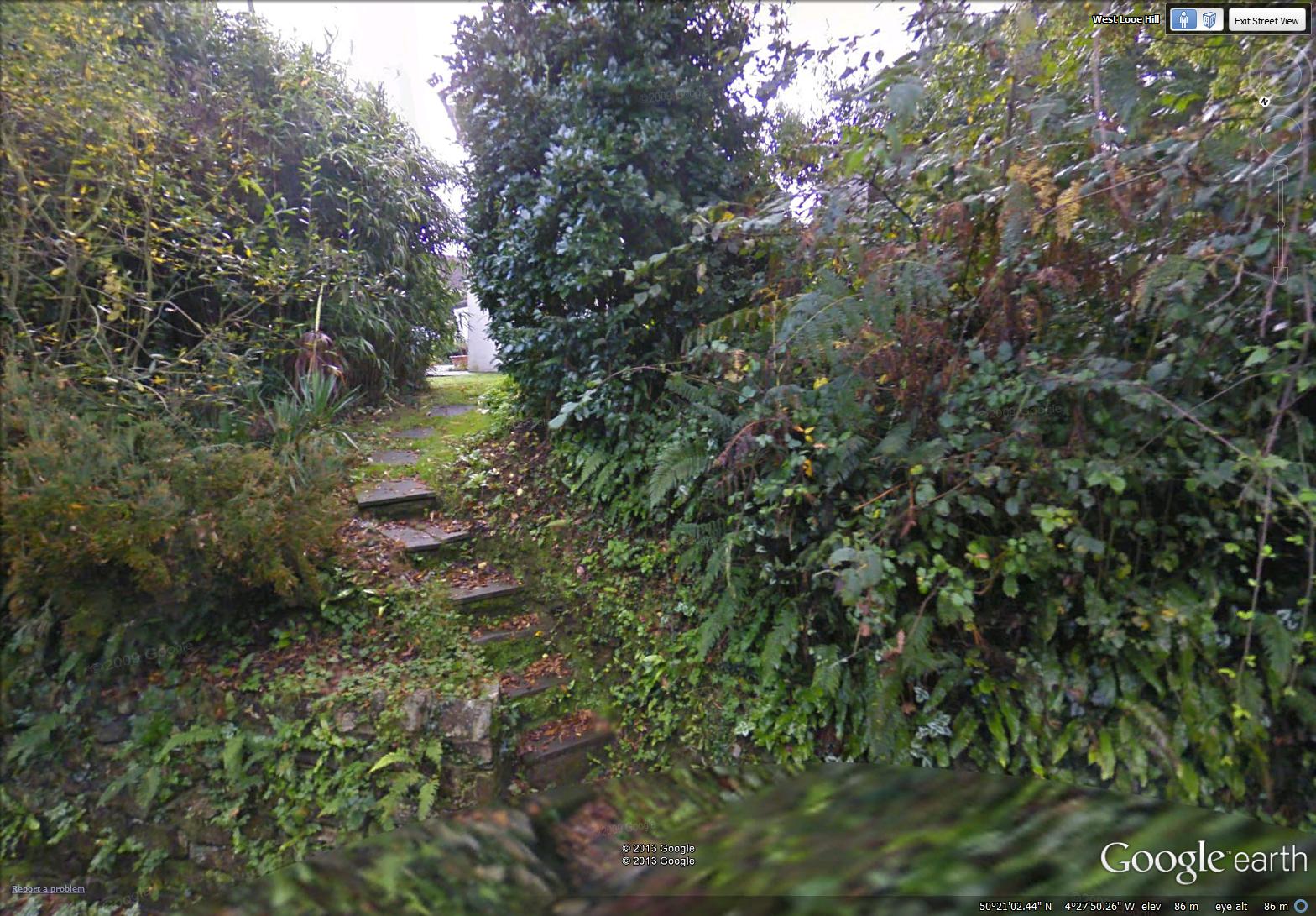
~
I think they blended well into a single painting …
~

July 15, 2013 ‘West Looe Hill’ Jane Tims
~
Copyright 2013 Jane Tims


