Archive for the ‘crossing the river’ Category
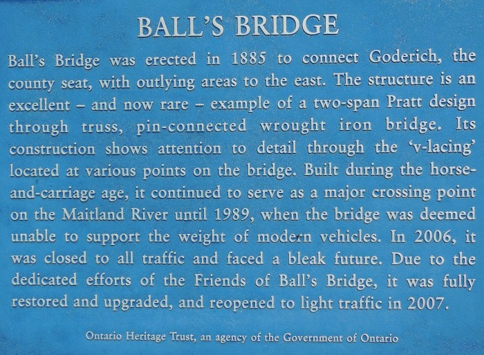
Ball’s Bridge’
In southern Ontario, the Maitland River winds through fields and woodlands before it empties into Lake Huron at Goderich.

When we visited the area two summers ago, we discovered the Ball’s Bridge on the Little Lakes Road.
~

~
Ball’s bridge was built over the Maitland River in 1885. It is a rare example of a two-span pin-connected Pratt through-truss iron bridge and one of the oldest wrought-iron Pratt bridges in the US and Canada. The bridge was built at a time when horse-drawn carriages and carts were its only traffic. In 2006 the bridge was declared unsafe for the weight of modern vehicles. In 2008, the bridge was saved from further deterioration and eventual destruction by the Friends of Ball’s Bridge.
~
~

The poem below tries to capture the interplay of light and shadow as we crossed Ball’s Bridge and drove the local roads.
~
Ball’s Bridge, Maitland River
~
on the first day of fall
landscape is criss-crossed
in lattice and wire
spider web and the flight paths
of pigeon-flutter
to the high lines
of the iron bridge
~
rays of light
find solar panels
and the backs of turtles
sunning on river logs
the inter-lacing
of dark water and light
the shadows of metal and truss
intercepting wire
~
cornfields
and winter wheat
embedded rows
a river and its valley
and a hawk follows
panels of air, first frost
and meltwater collects
on oval lily pads
yellowed leaves
rusted wire
~
~
This is the second metal bridge we have visited in Ontario. A few years ago we photographed the South Nation River Bridge, in Glengarry County, not far from Cornwall. That bridge has been removed, another loss from our built landscape. For the story of our visit to the South Nation River metal bridge click here
~
All my best,
Jane Tims
low, low water
This year, in New Brunswick, we are happy to see the rain at last. The dry weather means forest fires are a concern and groundwater levels are very low. We hope for regular, soaking rains in the fall, to help recharge our groundwater.
~

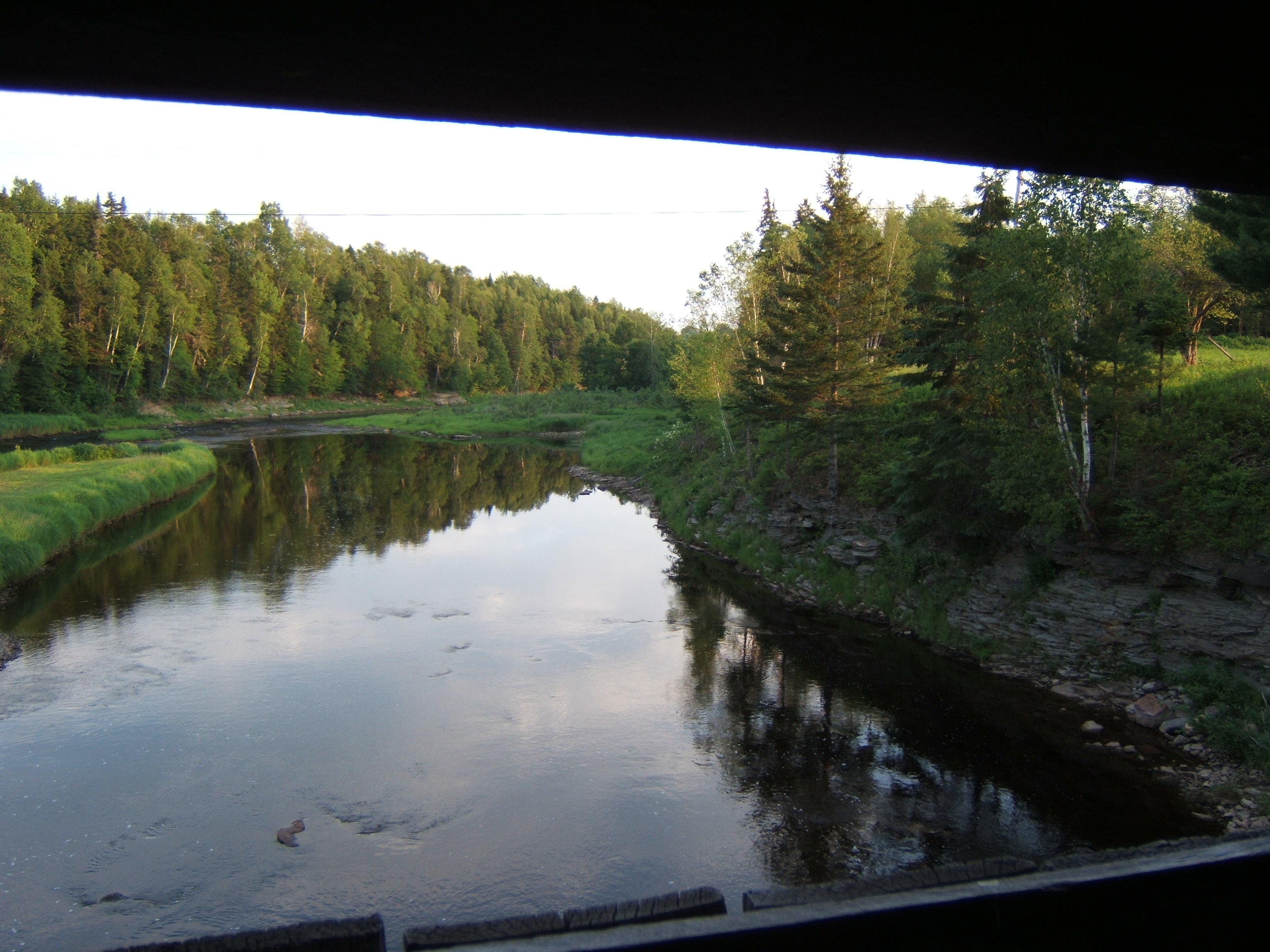
low water of the Rusagonis Stream, viewed through the ‘windows’ of our covered bridge
~
Many streams and rivers in New Brunswick are at their lowest flows. We were in a similar situation this time last year. Low water means wading only, no canoeing in the Rusagonis Stream. Some of the stones in the photo above have never been seen above water before. Low water is of concern for fish since the shallow water means water temperatures get too high for them.
~

the brown crescents in the river are sand bars, only revealed at low water
~
Even the Saint John River is so low we are seeing sand bars where deep water usually flows.
~
We had a good soaking of rain at the beginning of the week, and there is more rain in the forecast, so I will end this post feeling optimistic, and by showing you a photo of my husband as a little boy, fishing below the covered bridge (now gone) on the South Branch Rusagonis Stream!
~

~
Copyright 2017 Jane Tims
Next painting for Isaac’s Way art auction …
On January 25, 2016, the 25th Art Auction and Sale at Isaac’s Way Restaurant in Fredericton, New Brunswick will come to an end. Only a few more days to own some reasonably-priced art and help kids-in-need. As of January 4, 2016 this 25th auction has sold 22 paintings and raised $7,600 for art lessons for kids. For a look at the paintings still available, visit http://isaacsway.ca/art/. To have a look at my submission to the 25th Art Auction, see my post for September 18, 2015 https://janetims.com/2015/09/18/art-auction-new-painting/
~
My next submission, for the Isaac’s Way 26th Art Auction and Sale, is a landscape. The piece features a view of the Saint John River, from the Nerepis Marsh at Grand Bay-Westfield towards the Westfield Ferry. It is entitled ‘across the bay’ (24” wide by 20” high, acrylic on canvas, unframed with gallery edges). This auction will run from January 27, 2016 to late May, 2016. The proceeds from the auction will go to sponsor kids-in-need. I am donating 50% of the proceeds from my painting to the charity.
~
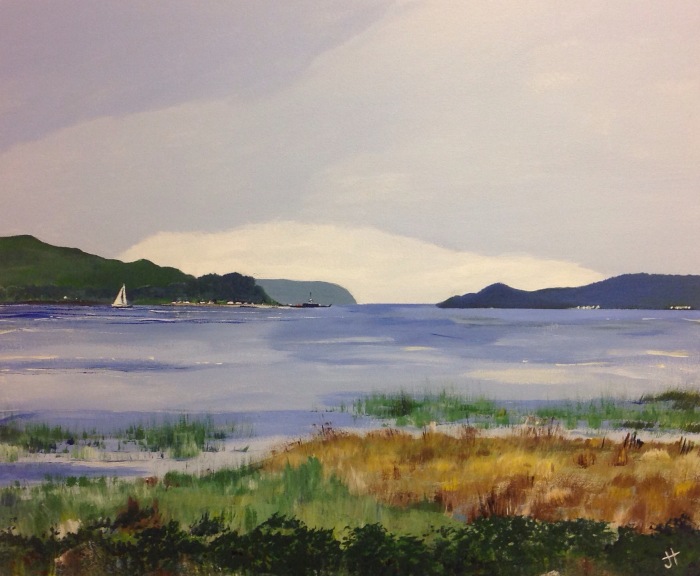
‘across the bay’ Jane Tims
~
Copyright Jane Tims 2016
in the shelter of the covered bridge – a narrow bridge
On our drive last weekend, we visited three covered bridges.
Usually our visits last at least an hour. At each bridge, we:
- get a good look at the abutments beneath the bridge
- watch and listen for birds
- identify the trees near the bridge and any wild plants in the vicinity
- photograph the covered bridge and any interesting architectural elements
- take notes about the state of the bridge, any new construction and the condition and covering of the roof
- look for animal tracks, holes made by woodpeckers, birds nests, spider webs and feathers
- record any notations in the bridge – carvings, chalk, felt marker, pencil, pen and paint
- make a list of the sounds I hear and try to absorb the ‘feeling’ each bridge evokes.
~
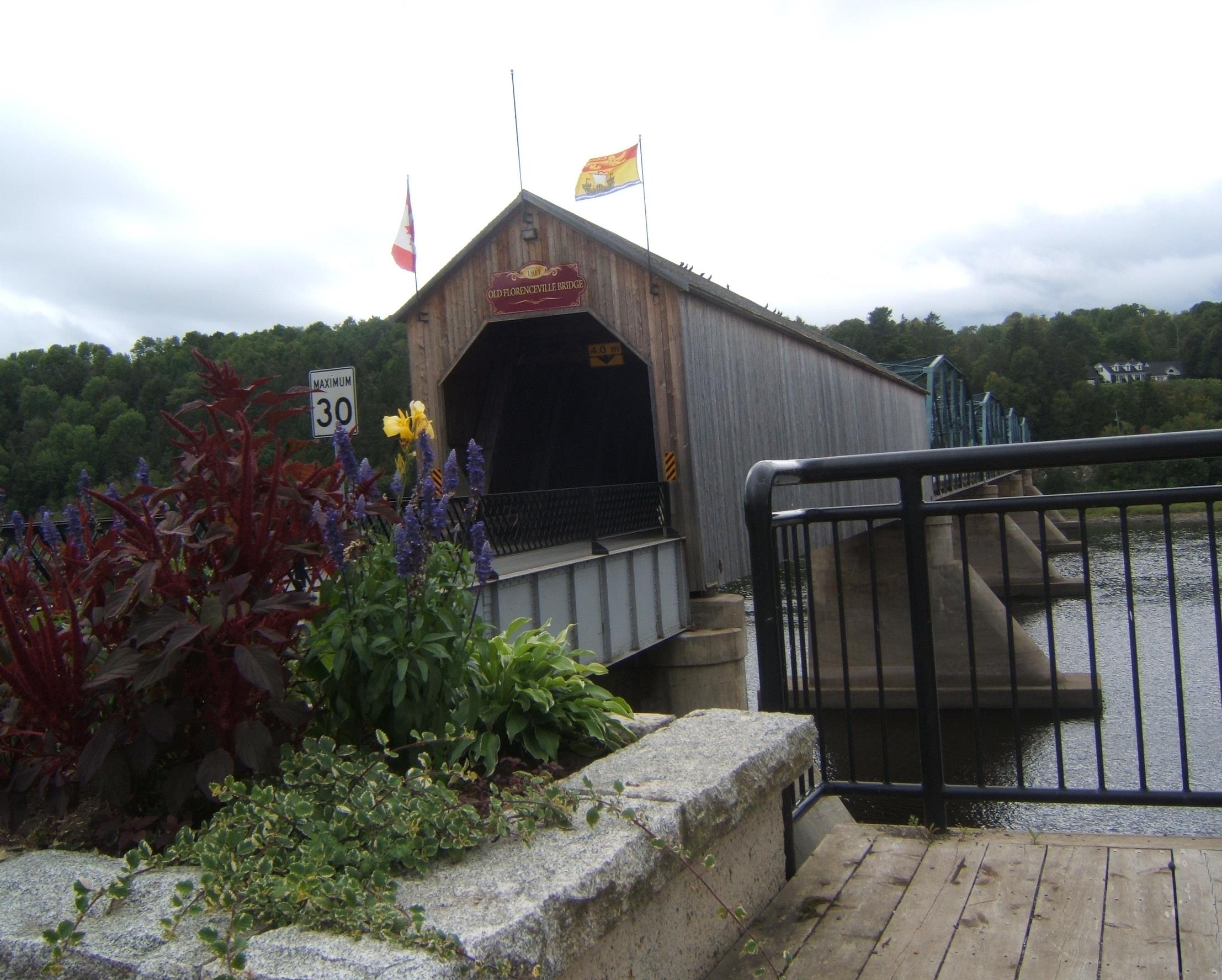
Florenceville Bridge, New Brunswick
~
I knew ahead of time, the Florenceville Bridge across the St. John River would be a different experience. Walking the bridge would be unlikely – there is no pedestrian walkway, the traffic is quite heavy and the bridge is narrow. I did cross the bridge in our truck, a harrowing adventure since the bridge traffic is two-way. Cars slow down when they meet, but the locals are seasoned to the width and scary-brave.
~

a red truck and a white truck meet and pass on the narrow bridge
~
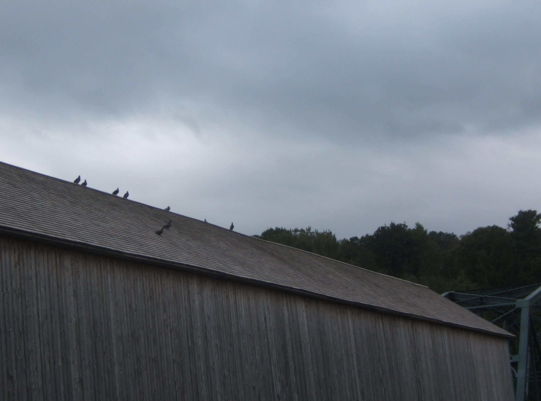
Only one span of the Florenceville Bridge is covered (built in 1907) and this is very well maintained. The other four spans are steel trusses. The pigeons perching on the roof of the bridge are its most obvious wild life.
~
~
~
keeping watch
(Florenceville Bridge)
~
fifteen pigeons swim through air
fill gaps on the ridge line
~
perch on the shingled roof
scrutinize the traffic
the squeeze of half-tons
on the bridge
the kiss of mirrors
~
pigeons quit the ridge, glide
to the shingled shore
~
river winds shiver
hawkweed and sumac, displace
blankets of wild cucumber, billow
the skirts and Tilley
hats of tourists
~

~
Copyright 2015 Jane Tims
a covered bridge – the Burpee Bridge, Queens County, New Brunswick
Last weekend, driving home from Miramichi, we followed the Grand Lake Road. It is mostly unpopulated, devoted to tree plantations and a preservation site for mature white pine.
~
Along the way, we stopped in at the Burpee Covered Bridge on the Gaspereau River near Gaspereau Forks, Queens County. This bridge is listed as Gaspereau River #2 in the April 1992 pamphlet ’Covered Bridges in New Brunswick’ (no author indicated). This means there was once another covered bridge crossing the Gaspereau River but it is now gone.
~

~
The Burpee Bridge was built in 1913. It is 167′ 9″ long with a span of 163′ 6″. The roadway width is 14′ 8″, and the load limit is 8 t. The maximum clearance is 3.9 meters.
The bridge is on a main road and the grounds on both sides of the river are nicely kept and mowed. The bridge was named for the family living nearby in 1913.
Inside the bridge, there is a window, with a good view of the Gaspereau River, showing the exposed bedrock of the river banks.
~
~
The rafters of the bridge are populated with swallows and their nests. The swallows chirped at me and swooped in and out of the bridge while I was there.
~
I couldn’t find any carvings in the failing light, but the inside of the bridge is covered in graffiti.
~

~
A lot of fluorescent paint has been used and it would be interesting to shine a black light inside the bridge … no doubt it would glow with spooky color …
~

~
We didn’t visit this bridge in 1992 as part of our Covered Bridge Project for Canada’s 125th anniversary. I am sorry we didn’t do more bridges that year … some are now gone, and it is interesting to compare the information for those that have survived.
~
This year, on July 27, the community plans a celebration of the 100th anniversary of the Burpee Bridge. The bridge will be turned (temporarily) into a museum of photos and artifacts about the bridge and community. Keeping our covered bridges in the eye of the community helps to preserve their heritage and value. It also encourages sharing of the wonderful stories about the part these bridges have played in our communities and lives.
~
Copyright 2013 Jane Tims
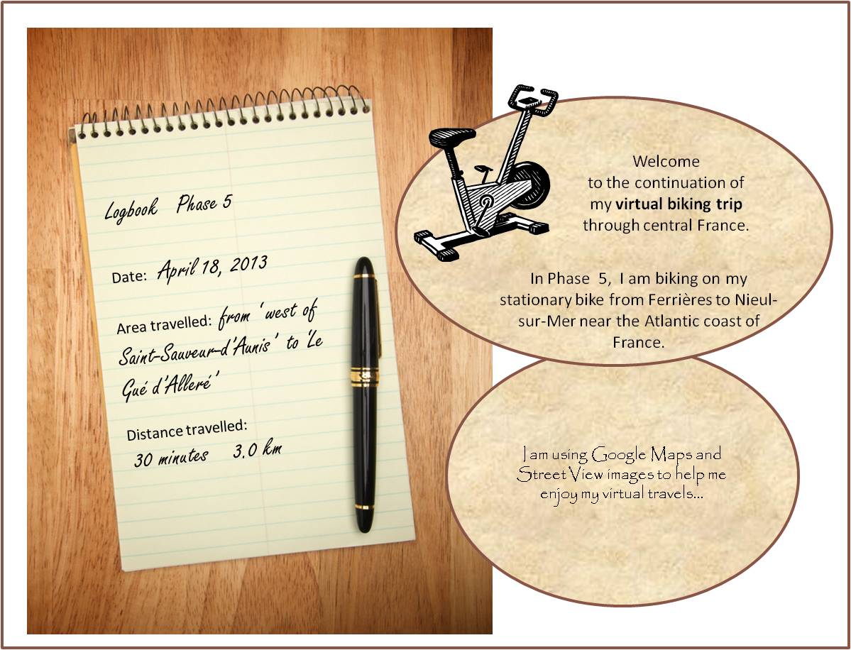
a ford in the river 5-3
~

houses in Le Gué d’Alleré (image from Street View)
~
~

map showing distance travelled (map from Google Maps)
~
April 18’s virtual bike ride took me through the town of Le Gué d’Alleré. A ‘gué’ is a place on a river where the water is shallow enough to allow easy passage, in other words, a ford.
The river in Le Gué d’Alleré was so shallow, it had no water at all. I know this river sometimes holds water since there is an image embedded in Street View showing the river full of water!
~

river in Le Gué d’Alleré (image from Street View)
~
When I was young, we often visited my grandfather’s farm in Nova Scotia. One of the places I remember well was the ford across the stream at the end of his road. The water was shallow at this spot and people from the community would bring their cars to the ford to wash them. It would not have been good for the environment. Soap suds and leaking oil and gasoline would pollute the downstream water, probably harming the aquatic life, including the fish people liked to catch.
~
~
ford
~
at the intersection
of the lane and the County Road,
a ford crossed the stream–
flat stones and riffles
~
in the shade of serviceberry and maple
we watched as distant cousins
washed their cars,
all suds and Daisies
~
then took clean cars
further down the road
(further down the stream),
for an hour of fishing
~
~
~
Best View: an image from my memory …
~

~
Copyright Jane Tims 2013
abandoned bridge – South Nation River
In south-east Ontario, the South Nation River winds through farmland…

Driving along the river in October of 2012, we found an old metal bridge, closed to traffic. Although left to rust, this bridge was beautiful in its simple construction. The deck of the bridge was rotted, but wildflowers had taken hold in the debris.
According to the South Nation River link at http://www.nation.on.ca/en/geocaching/ (South Nation Conservation), the bridge has now been removed.

~
~
abandoned bridge, South Nation River
~
years since I crossed the metal bridge –
we take the long way now,
over that engineered, concrete
contrivance, upstream
~
the old bridge CLOSED, of course
trusses red with rust, corroded
pitted as the river bank
and its swallow-burrows
~
once we walked those girders
leaned from the railings
amused ourselves by pitching rocks down
into the duckweed
~
wouldn’t be safe today, the deck
rotted where hawkweeds bloom
all summer, cheerful
you’d think they’d been planted
~
~
Published as ‘abandoned bridge, South Nation River’, Canadian Stories 15 (85), June 2012.
Copyright Jane Tims 2012

a walk through the covered bridge – disappearing covered bridges
Last week we took a drive to re-visit some of the covered bridges we saw in 1992 as part of a special project to celebrate Canada’s 125th birthday. One of these was the Stone Ridge Covered Bridge (formally known as Keswick River #6), crossing the Keswick River at Upper Stone Ridge in York County. I was looking forward to seeing the bridge because we had recorded some interesting carvings in 1992. Among the usual initials, someone had craved the images of three houses, one with steps and two chimneys, and one, a cottage, on the sill of the bridge window.
A short drive on a pretty country road along the Keswick River brought us to the bridge… a metal Bailey bridge, constructed to cross the river at the point where the covered bridge had once stood. The new bridge was sturdy and had its own charm, but it was so disappointing to know the old covered bridge was gone forever. The Stone Ridge Covered Bridge was lost to fire on October 10, 2008.

The Stone Ridge Covered Bridge was built in 1914 and had a span of 123′ 4″ and a total length of 126′ 4″. It had a roadway width of 14′ 10″ and a capacity of 10 T.
I wrote in our journal, on May 1, 1992: “most carvings were on the flat of the horizontal plate that formed the window sill and ran the length of the bridge”.’ I also wrote: “lots of hacking and hewing done on the window part of the sill”. The oldest date we recorded was ‘May 9, 1951 VHA’.
Some of the other carvings on the bridge in 1992 were: ‘LA + LB’, ‘WLR 54’, ‘VHA MARCH 7, 1952’, ‘1951 [or 1957] MAY 7 WLB [and a small heart]’, ‘KM 1952’, ‘KMB 9/55’, and ‘BB 1951’. There was also a separate carving of an upward arrow beside a ‘B’ and on the next line, ‘KM A4 54’.
I wonder who was VHA and how often did he or she return to the bridge over the years? Who was KM in 1952, and did she return, married, in 1955 with her new last name beginning with ‘B’? Was she married on April 4, 1954 to ‘B’? A mystery, perhaps solvable by looking into some local marriage records?!
It is sad to see the covered bridges in New Brunswick disappear, one at a time. Some are lost due to the dramatic power of the spring freshet. Others are lost to vandalism (fire) – every Hallowe’en residents keep a careful watch on the covered bridge in our community. In 1992 when we did the covered bridge project, our list had 71 covered bridges. The New Brunswick Department of Transportation website http://www.gnb.ca/0113/coveredbridges/coveredbridges-e.asp says there are presently 61 covered bridges in New Brunswick.
~
Copyright Jane Tims 2012
a walk through the covered bridge – Falls Brook Covered Bridge, Falls Brook on the Nackawic River
On May 16, 1992, we visited the Falls Brook Covered Bridge in York County as part of our project on covered bridges for Canada’s 125th anniversary. The Falls Brook Covered Bridge, on the Nackawic Siding Road at Nortondale, is also known as the Nackawic Siding Covered Bride, and is formally known as Nackawic River #5. This means that there used to be at least four other covered bridges crossing the Nackawic River or its tributaries, but they have been lost for various reasons.
This past weekend, we visited the Falls Brook bridge again, to see if it is still there. The sign at the end of the road was hopeful, indicating a covered bridge could be found on the road. Most of New Brunswick’s covered bridges are marked by these signs. 
My notes from 1992 said the road to the bridge was in poor shape – ‘spooky but very pretty and other-worldly’ was what I wrote. The road has deteriorated over the years to become a narrow track with deep potholes and large outcroppings of rock.


The bridge was still there, tucked in among fir and maple woods. It had been renovated within the last couple of years, based on the presence of some new large timbers and completely new wood siding.

The Falls Brook Covered Bridge was built in 1927. It is 63′ long, with a span of 60′. It is 14′ 10″ wide and has a maximum load of 8 T. The height clearance is 4.0 m. The architecture of the bridge is amazing, showing brace and beam construction with various hardwood joinery.

Unfortunately, the renovations have removed many of the markings we noted in 1992. At that time, the oldest dates were a carved ‘1885’ and, in black ink, ‘Ptarmigan hunter Ray Brown May 12th 1896 Horse had bad leg’. I have asked a well-informed birder about this and he told me there are no other records of ptarmigan in New Brunswick. Other carvings we noted in 1992 included: ‘M.A.K.’, ‘WDH’, ‘Colin + BrenDa’, ‘Could be fishin’ ‘ , ‘D C ‘ and ‘TOGETHER AGANE Betty and Johnathan’.
The markings from the 1800s were gone, but ‘D.C.’ was still there, as well as some interesting new markings.


Some show that height is no barrier to leaving your name!

If you have covered bridges in your area, take note of the markings people have left behind! Your record may be all that survives!

~
Copyright Jane Tims 2012
a walk through the covered bridge – Bell Bridge, South Branch of the Oromocto River
Another covered bridge crossing the South Branch of the Oromocto River is the Bell Bridge near Juvenile Settlement, Sunbury County (listed as South Oromocto Rover #3 in the April 1992 pamphlet ‘Covered Bridges in New Brunswick’, no author indicated). This bridge was built in 1931. It is 126′ 4″ long with a span of 123′ 4″. The roadway width is 15′ 5″, and the load limit is 10 t (6 t for double axle vehicles). The maximum clearance is 3.7 meters and a metal height barrier has been installed to ensure trucks exceeding the clearance cannot proceed through the bridge since this can do significant damage to the bridge structure.

The water at this point in the river is shallow and clear. I watched for a long time to see a fish, but they will be hiding in the cooler waters of the deeper pools.


We visited this bridge on April 26, 1992 as part of our Covered Bridge Project for Canada’s 125th anniversary.
In 1992, we found many carved initials inside the bridge, on the various timbers. The oldest date we found was ‘April 3, 1932’. Some of the other initials included ‘LYL May 1, 1932′, RPC [perhaps PRC] June 6 /32’, ‘RS ’77 ‘, ‘ RT MAY 49’, ‘RM AUG 38’, ‘EK’, and ‘AE Mc APR 3/32’. We also found the initials ‘A.K.O.G. APPI 35.’ with the ‘O’ written as a diamond.
On our August drive, I noticed two unrecorded inscriptions: ‘ALIE 69’ and ‘M.O. L R.A.’

I also found a large carved ‘S’, very hard to see…

the ‘S’ is hard to see, just above the knot and about three times the length
Do you suppose ‘M.O.’ still loves ‘R.A.’ ?
~
~
forever
~
we carve our initials
in the beams of the covered bridge
pledge our love to endure
~
but these words may
outlast the love
even the people
~
~
Copyright Jane Tims 2012


