Archive for the ‘the landscape of home’ Category
a bay and a bar (day 7 to day 10)
Today I am happy to announce – it has been one year since I began my virtual travel, as part of my efforts to exercise and to motivate me to ride my stationary bike more regularly. Although I have really only biked in my tiny exercise room in our basement, I have travelled, with the help of Street View (Google Earth) to central France, to the south coast of Cornwall and, now, to northern New Brunswick. During the past year, I biked 143 days (an average of 30 minutes on each day) and over 530 kilometers. I am so proud of myself!!
~
During the last four days of my virtual biking, I went through the Town of Dalhousie, at the mouth of the Restigouche River. At this point, the river opens into the Bay of Chaleur (la Baie des Chaleur) …
~
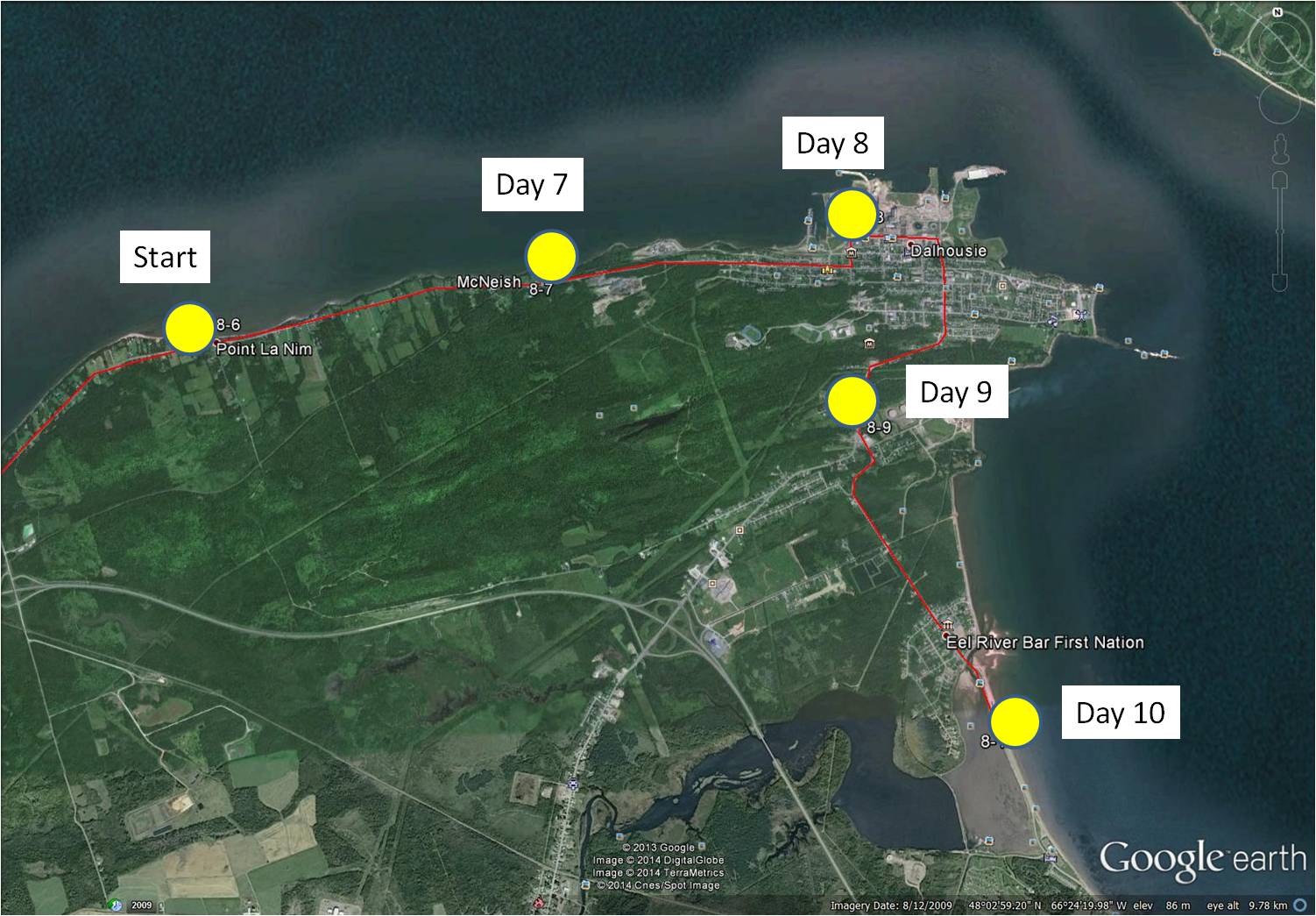
8-7 January 21, 2014 30 minutes 3.0 km (Point La Nim to McNeish)
8-8 January 23, 2014 30 minutes 3.0 km (McNeish to Dalhousie)
8-9 January 25, 2014 30 minutes 3.0 km (Dalhousie to Darlington)
8-10 January 28, 2014 35 minutes 3.0 km (Darlington to Eel River Bar)
~
One of the sights along this part of my journey is the 315 MW power generating station at Dalhousie, once operated by NB Power. This generating station was decommissioned in 2012 but remains interesting to me since I was hired in 1978 to monitor the biological effects of air emissions of the various industries in the Province. One of the reasons I travelled in northern New Brunswick was to carry out a monitoring program to study the effects of the Dalhousie power generating station.
~

Dalhousie power generating station (image by Street View)
~
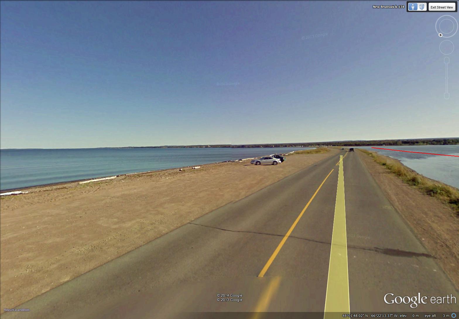
At the end of my four day ‘virtual travel’ last week, I crossed the beautiful Eel River Bar. This is the location of the Eel River Bar First Nation (Mi’kmaq people). The sandy bar is a barrier beach and one of the longest natural sand bars in the world. Water on one side of the Bar is salt and on the other is fresh. The highway is built directly on the Bar …
~
~
Across the Bay from the Bar is the low-lying peninsula of Miguasha, Quebec and the backdrop of the hills and mountains of the Gaspé peninsula. Boats at the entrance to Eel River are tethered as part of a fish netting system …

February 2, 2014 ‘boats at Eel River Bar’ Jane Tims
~
Copyright 2014 Jane Tims
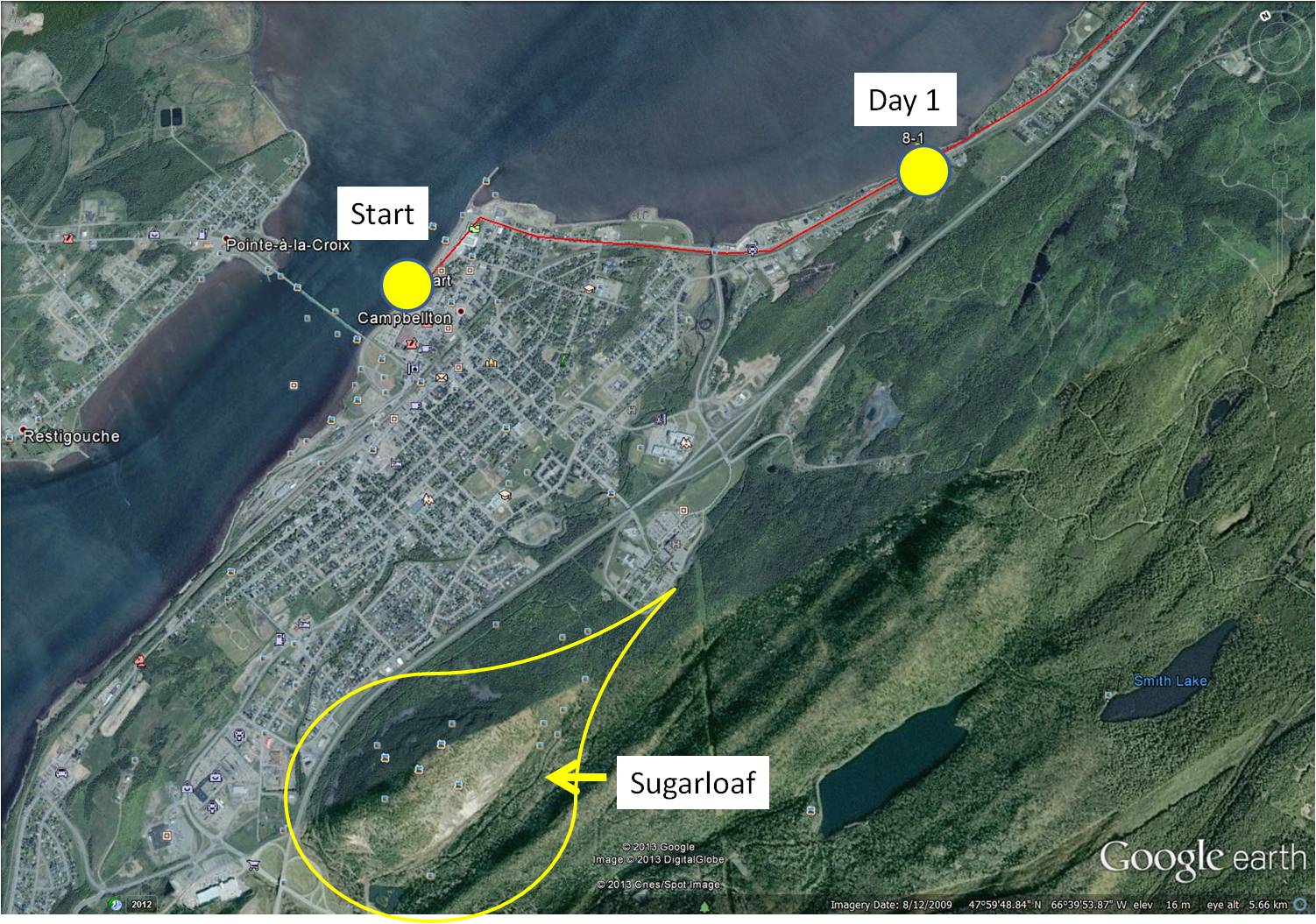
a leaping salmon and a mountain (day 1)
On December 31, 2013, I started on Phase 8 of my virtual cycling program. In this Phase, I am going to ‘travel’ on my stationary cycle along the north shore of my own Province, New Brunswick. I decided to start in the City of Campbellton because I have so many pleasant memories of working and vacationing in that area. Most of the roads I am ‘cycling’ in Street View, I have driven in reality, so most scenes are familiar.
~
8-1 December 31, 2013 35 minutes 3.0 km (Campbellton to Richardsville)
~
I began at a familiar landmark in the Campbellton area, the statue of the leaping salmon. The Restigouche River is world famous for its Atlantic Salmon population so the salmon is a fitting symbol for the area. In 1999 when my husband, son and I vacationed in the Gaspé of Quebec, we stopped here for a photo before leaving New Brunswick.
~
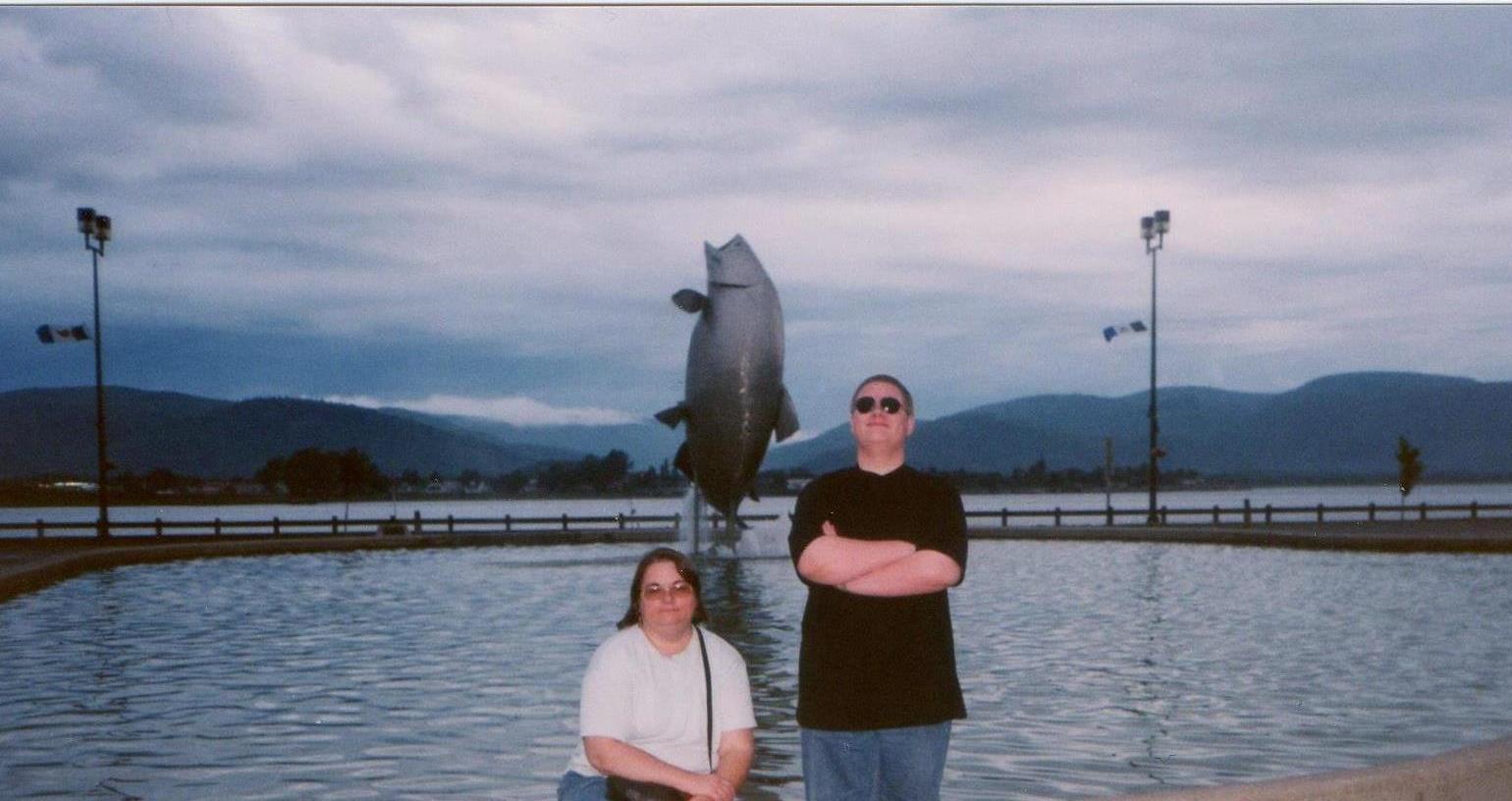
my son and I in front of the leaping salmon in 1999
~

start of my 2014 virtual cycling trip (image from Street View)
~
Across the street from the leaping salmon (and visible in the photo of my son and me) are the waters of the Restigouche River and the distant hills of the Gaspé. Since these will be with me for the first few days of my virtual adventure, I took a side trip a few kilometers inland for the subject of my first watercolour – Sugarloaf Mountain.
~
Sugarloaf is 281.1 meters in height, a part of the Appalachian Mountains and of volcanic origin. The mountain is within the City limits of Campbellton and is the location of Sugarloaf Provincial Park. Sugarloaf is the site of a ski resort, hiking and cross-country ski trails and a system of mountain biking trails.
~
In the late 1970’s and early 1980’s I climbed Sugarloaf a few times, gathering plants for air quality studies. I’ll talk more about those hikes as I proceed on my virtual trip since I have many memories of working in the area.
~

December 31, 2013 ‘Sugarloaf, New Brunswick’ Jane Tims
~
~
Although I enjoyed my virtual cycling in France and England, I find I have a more accurate perspective and sense of scale as I travel in New Brunswick. I am looking forward to showing you some of the beautiful scenery along the Restigouche River and la Baie-des-Chaleurs!
~
Copyright 2014 Jane Tims
a snippet of landscape – glacial erratics and boulder fields
Last week we went for a drive to explore some of the back roads in Sunbury County. As we drove, we encountered large boulders everywhere along the road. I know from my reading and a course years ago, these are a remnant of the glaciers that once covered this area. Large boulders were carried along by the ice and deposited on the landscape far from their place of origin.

In one place, a clear-cut lay the landscape bare and we were able to see how frequently these glacial erratics occurred in the area. In the photo, you can see the boulders scattered in a ‘boulder field’. These boulders would have been deposited here by a glacier, thousands of years ago, perhaps during the Wisconsinan glaciation when almost all of Canada was covered by ice.

It is strange to drive along the road today and know that thousands of years ago, a sheet of ice, perhaps a few kilometers thick, would have covered us.
~
~
gravel pit
~
ten thousand years it took
a glacial stream to set
the sinew of the esker –
cobbles sorted to layers,
screened by a giant hand
~
ten scant years to sever
esker snake from his tail –
the excavator bucket
reaching, fingers lifting sand,
pit-run, ready for road
~
~
Copyright Jane Tims 2012
Serviceberry (Amelanchier sp.)
In the corner of our property is a usually-inconspicuous bush struggling to become a tree. This time of year it comes out of anonymity in full bloom. Today it is covered in white flowers – in a week it will be a scattering of confetti on the ground.

This bush is one of the Amelanchier species, probably Amelanchier sanguinea var. alnifolia (Nutt.) P. Landry. Amelanchier is perplexing to identify to species because of hybridization and other complex genetics. It has many common names, including Serviceberry, Wild Pear, Juneberry, Shadbush, Wild Plum, Sugar Pear, Saskatoon, and Chuckley Pear. In French it is called poiriers or petites poires. It is called Shadbush because it blooms at the same time the shad are running. The American Shad is an anadromous fish caught as it makes its way up the rivers for spawning.
Amelanchier is often found on disturbed sites, along roadways and fields. It also likes the edges of thickets and wet areas. This time of year, it beautifies the landscape with frail white bloom.
The fruit of Amelanchier is a berry-like pome, dark purple in color. Each berry contains 10 seeds and the sepal is persistent on the blossom end of the berry. The berries are edible and sweet, and can be eaten raw or used to make jam.
~
~
the shad are running
~
after the hard rain
and the wind between cold front and warm
the river runs brown
and for dinner we have fiddleheads
new potatoes and shad,
and last-July’s Serviceberry jam
~
Serviceberry bushes are torn fish nets
holes poked through with fingers
petals scattered on mossy stones
along the river shore
~
~

Warning: 1. never eat any plant if you are not absolutely certain of the identification; 2. never eat any plant if you have personal sensitivities, including allergies, to certain plants or their derivatives; 3. never eat any plant unless you have checked several sources to verify the edibility of the plant. © Jane Tims 2012
accents in red
We are still in the greys and browns of spring.
There are a few wildflowers blooming. The Coltsfoot is spreading carpets of yellow along the roadside. And flowers in the deep hardwoods have begun to display their delicate beauty. But most places are drab and colorless.
I watch for red this time of year. There are a few red berries, still clinging to their branches after winter.


And the stems of Red Osier Dogwood (Cornus stolonifera Michx.) are brilliant in the fields and ditches.

My favorite ‘red’ of spring is the muted red of the blueberry fields.

~
~
fancy
~
the blueberry barren
is faded scarlet
red osier in ditches
rosebush and hawthorn
a single berry, a single haw
Earth in brown
toenails red
~
© Jane Tims 2012
snippets of landscape – ice falls on rock walls
When highways are built, they often cut through the bedrock, leaving rock walls along the margins of the road. If these intersect a brook or seep of water, the result is a waterfall on the face of the rock. In spring or summer, rains can create wild cataracts. In winter the water freezes, building frozen walls of blue-shadowed ice. In sunlight, especially when they begin to melt, these ice falls are dazzling.

~
~
one warm hand
~
icicles seep between
layers of rock frozen
curtains separate
inner room from winter storm
glass barrier between blue
light and sheltered eyes
memory of water flows
along the face of the rock
one warm hand melts ice
consolation, condensation
on the inward glass
~
~
© Jane Tims 2012

snowdrift
Wind is not visible, yet we can describe the shape of the wind. Along the shores of our lakes, White Pines are wind-blown into irregular forms to show the direction of the prevailing wind. In my poem ‘Clear Lake’ (see the post for August 26, 2011, ‘deep waters – Clear Lake’ under the category ‘waterways’), I describe these as “group of seven trees/ flung southward”. Artists from the Group of Seven were famous for their depiction of this symbol of the Canadian wilderness. A good example is the painting ‘White Pine’ by A.J. Casson.

'White Pine' by A.J. Casson, from the book 'Images of Nature: Canadian Poets and the Group of Seven' compiled by David Booth, Kids Can Press, Toronto, 1995.
In winter, the shape of the snow also captures the three dimensional form of the wind. The easiest manifestation of this is the way horizontal surfaces record the direction of blowing snow.

Snowdrifts form as the wind blows quantities of snow into shapes resembling dunes of sand. As kids on the prairie, we loved these snowdrifts since we could tunnel in them and build fantastic snow shelters. Today, I can watch the drifts build across our lawn and transform its flat surface into the artistry of the wind.
~
~
Drift
~
after the storm
snow heaps
high against the wall
fingers of the wind sculpt
etch shadows
into vacant white
~
sunshine flashes
summons prisms
from hollows of snow
warmth shivers through the drift
crystal
into cataract
~
a tendril of snow
clings
damply to the wall
a lingering winter ivy
~
~
Published as: ‘Drift’, 1994, The Cormorant (Fall 1994) XI (1)
revised
© Jane Tims 2011

firepit
Our firepit has a roaming spirit. It began its days in front of the house and we had many wonderful evening fires. Then, as the years passed, the maple tree overhead grew until it was dangerous to have a fire under such a thick canopy.
To improve the safety of the firepit, I moved it, stone by stone to the back of the house, reassembling it exactly as it was. We had a few fires and then, one day, our lives became busy. We kept taking wood for the next fire and the next fire never happened. Gradually the pile became so large, you could not see the firepit!
Last month, my husband put our tractor to use to move the firepit one more time. I clawed my way into the pile of scrap wood and uncovered the stones. Then we pushed them into the bucket of the tractor and away they went, to their new home across the yard.

Now they are in the driveway, waiting for their new home (see the plan in ‘plans for a rocky road’ November 13, 2011 under the category ‘the rock project’).

The next step will be to fell four spruce trees in the area of the firepit, to make sure we can have our fires safely. This next step may have to wait until spring since the stones are now in the frozen throes of winter!

fire
~
rattle of leaves
bark, twigs
and paper
as the air warms
finds its chimney
surges red life
into the tunnel of maple
the moment when breath
turned cloudy on cold air
becomes smoke
and lungs draw ash and fire
~
the summer night
when lightning strikes
when thunder
bold in its dreaming
turns beneath the earth
ions leap
and pine sap explodes
in a fistful of sparks
~
the warming by smiles
and clasping of hands
striking of sparks in the tinder
the flame leaps
from candle to candle
~
the sharp ache
at the corner of an eye
where cinders and smoke
have gathered
lungs drawing fire and ash
an effort to breathe
and fingers
warm with tremble
~
© Jane Tims 1995

spending time out-of-doors
Do you spend enough time out-of-doors? Some researchers believe if you haven’t seen a ‘fractal’ today, you aren’t as well as you could be!
The word ‘fractal’ is relatively new. My desk-side dictionaries, a Webster from 1979 and an Oxford from 1998 do not have this word. According to the on-line Oxford Dictionary, a ‘fractal’ is a curve or geometrical figure, each part of which has the same statistical character as the whole. The word ‘fractal’ comes from the Latin fractus meaning ‘to break’.
In nature fractals occur frequently. All fractals are self-similar – the ‘whole’ has the same shape as its parts. For example, the tributary of a river has the same sinuous shape and properties of the larger river. Also, the leaflet of a finely-divided fern has the same shape as the whole frond.

Bracken fern with fractal leaf patterns... the leaf is divided into leaflets... these are divided into sub-leaflets... and these are divided into lobes...
Benoit Mandelbrot is the mathematician credited with first describing fractal geometry.
Other fractals in nature include mountains, branching patterns of trees, the dendritic form of root systems, patterns of vessels in the body, frost crystals and snowflakes, even the clustering of galaxies. Just go on a walk outside to find lots of your own examples of fractals.

fractals in branches of Balsam Fir...
When we do not include nature in our lives, we miss these fractals. If experiencing fractals in nature is necessary for human wellness, as some suspect, this is yet another reason for getting out-of-doors, examining the patterns we see in trees and other wild plants, taking in the scenery of landforms and horizons, and catching snowflakes on mittens.

fractals in tree branches and fractals in clouds
fractals
~
winter trees on morning sky
each a watershed, dendritic weave
brooks and rivers
backwaters and waterfalls
~
the trunk a river
not flowing to the sea
but into earth toward
unsalted water, deep in the ground
~
the roots the mirror of river
knowledge gathered
drawn, divided
to fine corpuscular thread
~
© Jane Tims 2005

monuments in stone
inuksuk n. (plural inuksuit) a stone landmark or cairn used by Arctic and northern peoples to mark a point of reference or a place of significance; an Inuit cultural symbol.
inunnguaq n. (plural inunnguat) a stone cairn in the shape of a human figure, meant to represent a human figure, and distinguished from an inuksuk.
Wikipedia.org
Our rock project is progressing slowly. We are collecting rocks for a stone monument. Since I want this to be a sculptural piece, I am sure the rocks we select will play a role in the final look of the monument.
One possibiity is to build an inuksuk. These stone landmarks are a part of the culture of the north, but they have caught the general imagination and are now encountered throughout Canada. On our trip out west, the inuksuk built along the Trans-Canada highway in Manitoba were particularly memorable.
For a few years, the inuksuk (plural inuksuit) and inunnguaq were common along the New Maryland highway in New Brunswick. On the stretch of road between New Maryland and Fredericton, the highway is carved through rock and outcrops are part of the roadscape. A women who walked along the road every morning for a few years was responsible for building many of the inuksuit. The local newspaper did a story on her, explaining that she walked and built the monuments as exercise following by-pass surgery. She wore a white jogging outfit with black splotches and was fondly referred to as the ‘Cow Lady’.
The ‘Cow Lady’ no longer walks the road and her inuksuit and inunnguat have fallen into disrepair. I remember her fondly and dedicate the poem below to her.
Inunnguaq 101
~
these are the hill people
sometimes without arms and legs
sometimes with other, alien parts
but proud
honor the woman who walks here
~
sometimes toppled
often reassembled
constructed one day at a time
optimism of increment
a community on the hillside
~
© Jane Tims 2004


