Posts Tagged ‘Saint John River’
a drive along the river
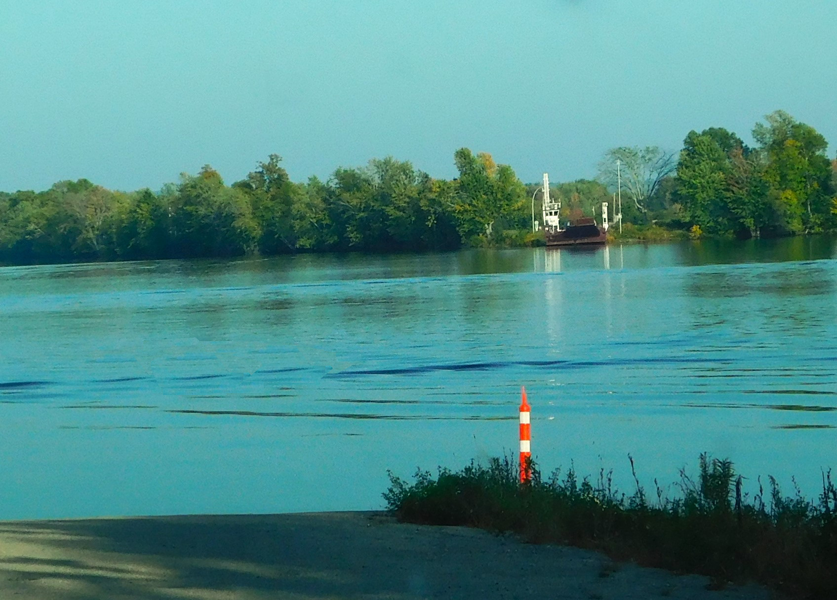
Two weekends ago, my husband and I took a favourite drive along part of the Saint John River in New Brunswick. The Jemseg Ferry Road is a short loop, beginning at the Scovil side of the ferry at Gagetown and continuing along a meandering road to Lower Jemseg. The area is a cluster of bogans, ponds and meadows where we often see osprey and eagles, ducks and turtles. Once, many years ago, we saw a glossy ibis and I added it to my life list of birds.
~
~
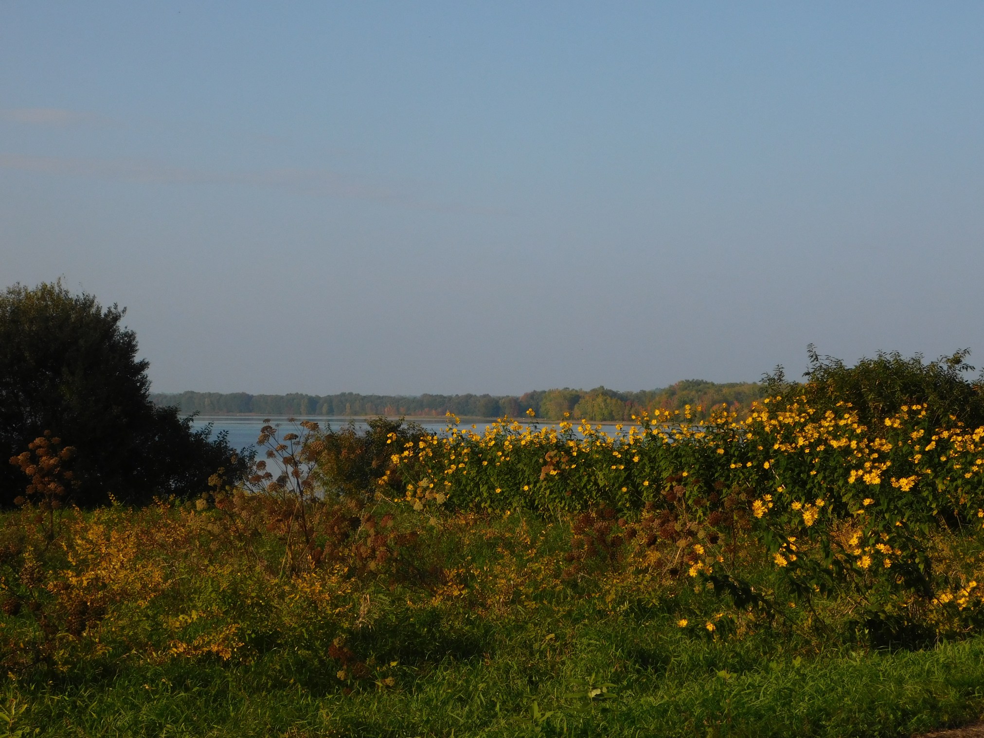
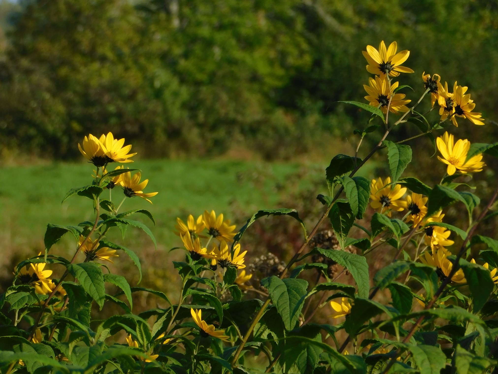
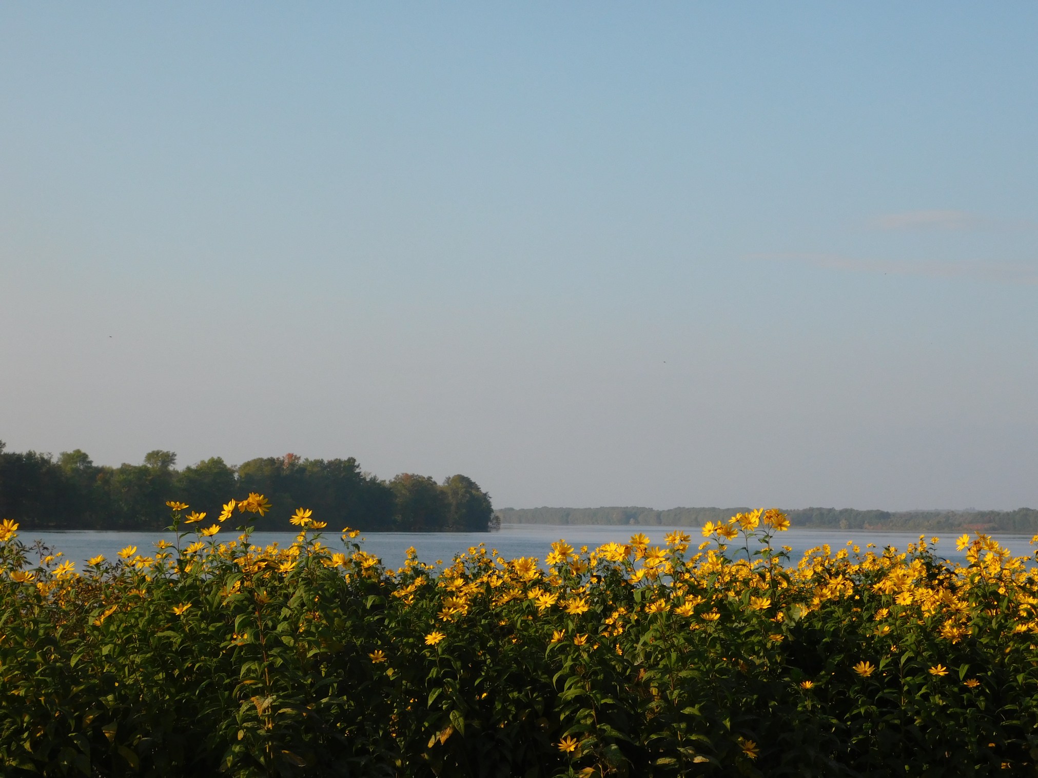
On our drive, we were amazed at the blooms of swamp (or giant) sunflower along the river banks. This sunflower has yellow petals (not dark towards the base), lanceolate (long narrow) leaves, alternate leaves, and a magenta stem. Helianthus giganteus, a relative of the cultivated sunflower, is not native but an escape. Crowds of the flowers followed the road and framed almost every view of the river.
~
~

~
~
The sun was setting as we drove along and the yellow flowers were all facing the west. This tilting of the flower head to follow the sun is known as heliotropism.
~
~
As you can see from the colour in the trees in the photos, we have only a short time to enjoy these beautiful fall flowers. We drove the same road just yesterday and most of the flower were already gone.
~
All my best,
Jane (a.k.a. Alexandra)
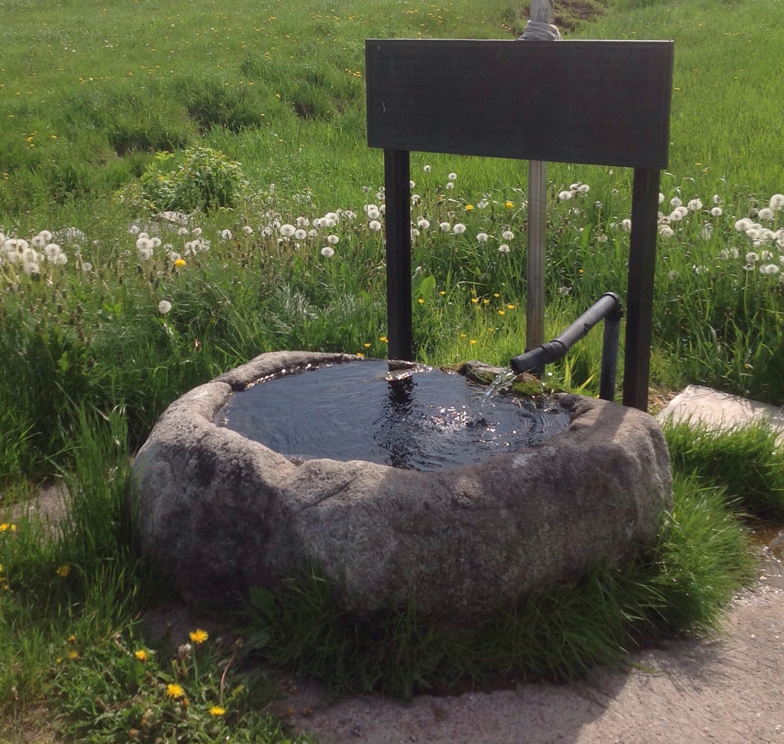
A granite water trough
One of my favourite drives is Route 102 in southern New Brunswick. It follows the Saint John River and goes through the villages of Hampstead and Evandale. There are many sights along the way, but one of my favourite stops is near Hampstead, at a road-side spring. The spring flows all year long and is distinct from other springs … the water flows cold and clear into a rounded trough carved from granite from a local quarry.
~
This trough was made from Spoon Island granite, hollowed out by Andrew Hamilton (1796 – 1882) … The trough is fed from a spring through a hand-bored wooden pipe. The spring is located on his 200 acre homestead.
~
~
For more information on rock quarries in south-western New Brunswick see a thorough paper by Gwen Martin, ‘ The Granite Industry of Southwestern New Brunswick: A Historical Perspective’ http://www2.gnb.ca/content/dam/gnb/Departments/en/pdf/Minerals-Minerales/PG_2013-1.pdf . The paper also describes the complex subject of granite rock, describes the sources of granite for many of New Brunswick’s beautiful buildings and monuments, and includes histories of some of our famous New Brunswick geologists including Loring Bailey (Bailey Hall on the UNB campus) and Abraham Gesner (Gesner Elementary in Oromocto).
~

A view of the Saint John River along a section of Route 102 …. our cabin is somewhere among the trees across the river
~
All my best,
Jane
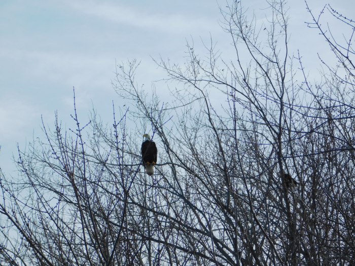
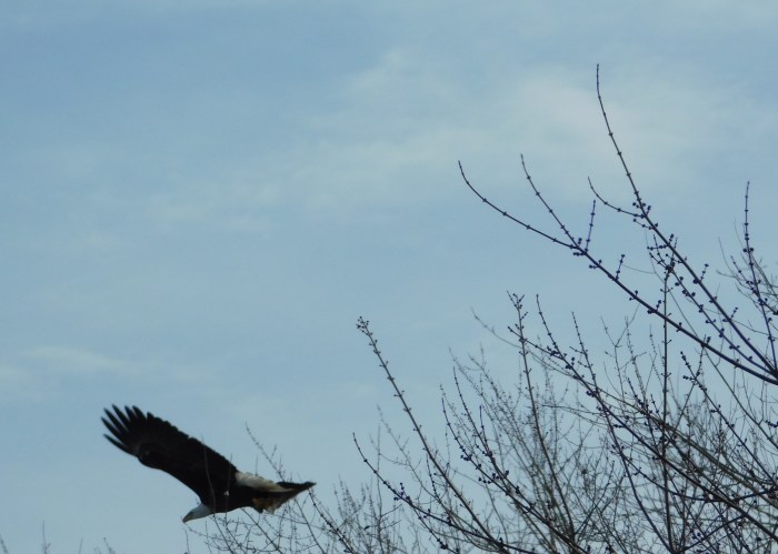
birdwatching on a winter drive
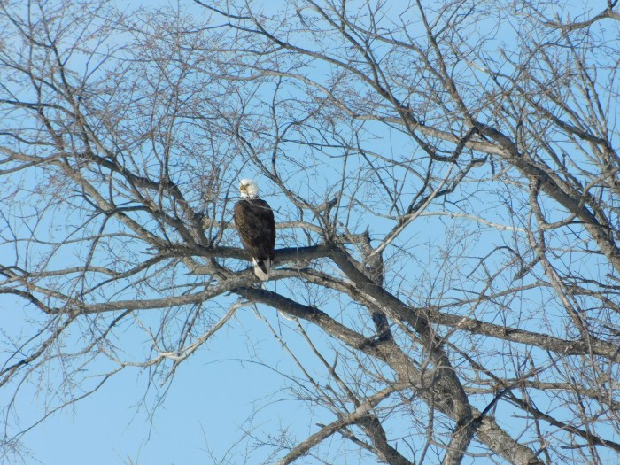
Yesterday we went for a drive along the Saint John River. As the snow disappears from the fields along the river, eagles and hawks sit in the trees to catch a glimpse of possible prey. Sure enough, as we approached the Jemseg Bridge, we saw a male Bald Eagle, looking twice his normal size due to fluffing of feathers against the cold (-4 degrees Celsius). Since Bald Eagles live an average of 20 years, this may be a bird we have seen many times in our drives along the river.
~

~
I missed a good photo the first pass, so we retraced our route between the Gagetown and Jemseg bridges and were rewarded when the first Bald Eagle was joined by a large juvenile.
~
~
As we watched him, he prepared for flight, either perturbed at us for pulling over or at the other eagle for moving into his tree. At last he took off and settled in another old tree just along the road.
~

~
~
These are magnificent birds, often overlooked in our area since there are large numbers living in the vicinity of our landfill and at various places along the river.
~
 ~
~
~
Copyright 2018 Jane Tims
low, low water
This year, in New Brunswick, we are happy to see the rain at last. The dry weather means forest fires are a concern and groundwater levels are very low. We hope for regular, soaking rains in the fall, to help recharge our groundwater.
~
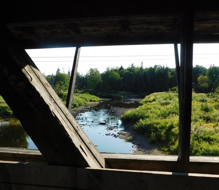
low water of the Rusagonis Stream, viewed through the ‘windows’ of our covered bridge
~
Many streams and rivers in New Brunswick are at their lowest flows. We were in a similar situation this time last year. Low water means wading only, no canoeing in the Rusagonis Stream. Some of the stones in the photo above have never been seen above water before. Low water is of concern for fish since the shallow water means water temperatures get too high for them.
~

the brown crescents in the river are sand bars, only revealed at low water
~
Even the Saint John River is so low we are seeing sand bars where deep water usually flows.
~
We had a good soaking of rain at the beginning of the week, and there is more rain in the forecast, so I will end this post feeling optimistic, and by showing you a photo of my husband as a little boy, fishing below the covered bridge (now gone) on the South Branch Rusagonis Stream!
~

~
Copyright 2017 Jane Tims
Bald eagle
On a drive along the Saint John River south of Oromocto, we were happy to get great views of two Bald Eagles.
~

an uneasy gathering on the river ice …
~
watching for dinner …
~
~
Copyright Jane Tims 2017
gates and gateposts
Looking through my watercolours, I came across the painting below of a gatepost. I painted this during my virtual excursion through Cornwall, using Street View and Google Earth. The painting reminds me of how much fun I had, painting the scenes I discovered on my virtual journey.
~
I am still using Street View to motivate my exercise program – since last year, I have been following the Saint John River from its origins in Quebec and Maine. My goal is to ‘cycle’ the length of the Saint John River, all the way to where it empties into the Bay of Fundy.
~
Gateways mark change. They represent movement from one space to another. They can be entryways. They can also be barriers. The challenge is always to step through that gate and keep on going.
~

Oct. 4, 2013 ‘gate near Feock’ Jane Tims
~
through the gate
~
grey granite cold
black body to
absorb the sun
emit no warm
even lichens
rooted to stone
are barely alive
~
the stone invites
admiration
but curves disguise
the jagged edge
biotite and
muscovite honed
razor thin
~
step forward, through
the gate, ignore
the risk
the path behind
~
~
Copyright 2014 Jane Tims
crossing the river #2
In the 1970s, when my husband and I had only known each other for about a month, we were stranded for three hours on a ferry that quit half way across the river. The ferryman just shrugged, said he’d be back, and rowed away in the lifeboat.
We were desperate. For an hour, we skipped stones across the water. I don’t believe there was a single stone or pebble or grain of sand left on the ferry deck! We talked, of course, and probably found out how much we had in common. We’ve been together for almost 33 years.
When the ferryman returned, he brought some sandwiches his wife had made for us and the news we would have to wait two more hours for the Coast Guard to come up the river from Saint John to tow us to the shore.
Needless to say, we were eventually rescued. And I have never experienced a ferry breakdown again.

some of these would be excellent for skipping
skipping stones
~
collect your stones
select for flat and smooth
stones with knowledge
embedded flight and float
pile your stones
~
hold your hand
like this, curl your finger
round the stone, flat curve against
your palm, coddled
cover of a book
you never want to end
~
swoop back
arm and index finger
parallel to shore, release
count
the
skips
the way
water
flirts
with edge
of skim
and
sinking
stone
~
concentric rings
connect and scatter
~
select another stone
~
© Jane Tims 2011
course of the creek
Our small cabin is near a lake, an offshoot of the Saint John River. We have what some would consider poor access to the lake, since there is a marsh between us and the lake shore edge. But that marsh is a very special place, ever changing and always interesting.
One way it changes, almost daily and certainly seasonally, is with respect to water level. You could say we are downstream of the entire Saint John River, meaning we are receiver of every fluctuation of the water level in the system. The situation is made complex by the influence of a major hydroelectric dam at Mactaquac.
In spring, the river floods, and the marsh is covered by water…
")
In normal years, the water levels become quite low, and our marsh is high and dry. We can walk on it, to reach the outer shore of the lake…

the green in the foreground is the marsh
In wet years, like this has been, the water stays high and there is a pond between us and the main lake…

On Saturday, I went rowing on the pond in my small red rowboat. I rowed out to the edge of the lake and then followed the deeper waters of the small winding creek back into the marsh as far as I could go without grounding the boat. Last year I could see pumpkinseed sunfish in the creek water, but not this time.
Most of the grasses in the marsh are Spartina pectinata Link., broad-leaf cord-grass, ordinarily associated with salt marshes. Actually, salt water is characteristic of the lower parts of the Saint John River – the salt water wedge extends as high as Washademoak Lake, and the tidal influence is measurable to above Fredericton!
At the outer shore of the pond, where the creek enters the lake, I was surprised and delighted to find a few stems of wild rice (Zizania aquatica L.). This is not native to New Brunswick, but is often planted along shores to attract waterfowl and is now found all along the Saint John River and in many lakes. The grass is distinctive because the pistillate (female) flowers are in a group near the top of the plant while the staminate (male) flowers are on horizontal banches below.
I am an awkward rower. Usually, to improve my control and reduce my speed, I row the boat backward, stern first! In spite of my lack of speed, it is an adventure to be on the water, to become a bit of an explorer. My need to know the ways of the pond reminds me of my attempts to understand the path my life has taken.
characteristics of creek
~
clumsy row in the marsh pond
to seek the course of the creek
the strand of water’s flow
to nourish pond define
its shape conduit
to the lake
~
a slender S through grass emergent
pondweed and cord-grass vague
deviation from clarity hyaline the interface
of freshwater and salt and pumpkinseed
turn their flat bodies to intercept
the flow find the break in the mat of sedge
narrow simplicity of weed-free bottom
~
search
and find
the inevitable
thread in flow of
story the theme to bind
the words and water into one
~
© Jane Tims 2011
crossing the river
In New Brunswick, the Saint John River watershed accounts for more than one-third of the province. It is a majestic river, almost 700 kilometers long, beginning in Maine and Quebec as small tributaries and gradually gaining in width and volume as it flows towards the Bay of Fundy.
One of the best things about living near the Saint John River is its cable ferries.

There are several bridges, of course, but no means of transport across the Saint John River can compare with the mini-voyage experience of crossing the river on a summer day with the wind in your hair and the dazzle of water in your eyes. It is always interesting watching the ferryman packing the cars in like sardines on the busy days. There is usually some interesting local event posted on the bulletin board. And New Brunswick’s river ferries are free to ride!
In 1978, I made several trips on a ferry that was only in operation for a short time. This was the car ferry at Cambridge-Narrows on Washademoak Lake, part of Washademoak River, one of the large tributaries to the Saint John River. It operated for a few months after the covered bridge there was flattened in the Groundhog Gale of February 2, 1976. The new bridge was built shortly afterward in 1978 and only local people remember the ferry.

However, I remember the ferry at Cambridge-Narrows very well. I wrote the poem ‘Lights on the Lake’ one evening as I took the ferry across the Narrows and felt the peacefulness of the small community winding down from the summer season.
For a short history of Cambridge-Narrows and a photograph of the covered bridge after it was destroyed by the Groundhog Gale, see
http://www.imagine-action.ca/IAAppContent/274/BookletVII_Legacy%20of%20HistoryFinal.pdf
Lights on the Lake
~
1.
~
twilight
fairy bulbs on masts
sunset on sail
amber to trace
the ferry’s quiet crossing
~
dusk
leaded porch lights
propane glow
twin headlights
joust along the cottage road
~
darkness
strings of lantern
patio voices, clinking and laughter
fires on the beach
sparks stirred toward the sky
~
moonlight
waves flirt with stars
Aurora Borealis leaps
fireflies blink
brief messages of love
~
2.
~
comes an evening at summer’s end crowd and fireflies are gone night storms shuttered windows
darkened doors the charred remains of fires
on the shore
~
and through the trees a ruby gleam
a choir practices its song
~
© Jane Tims 1978


