Posts Tagged ‘carvings’
in the shelter of the covered bridge – messages left in the bridge
On our latest drive to see the covered bridges in the watershed of the St. John River, we visited four bridges near Sussex.
~
The Urney Covered Bridge (Trout Creek #4) is a relatively small bridge (20.1 meters in length) built in 1905.
~
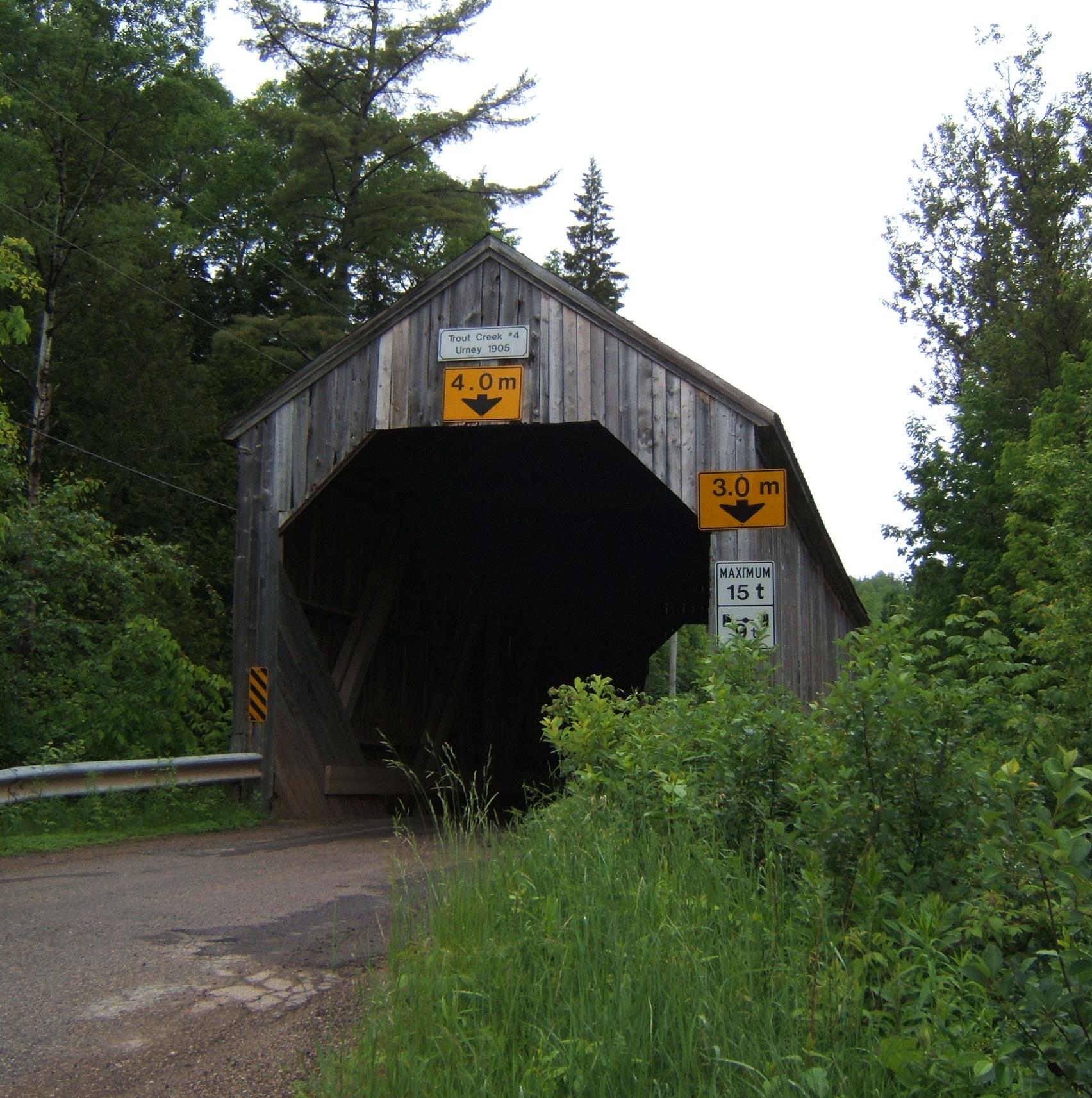
The Urney Covered Bridge (Trout Creek #4) in Kings County. New Brunswick
~
The water of Trout Creek is clear and cold – at one end of the bridge is a small sandy beach. The bottom of the stream is mottled with bands of pink bedrock.
~

sandy beach along the Trout Creek, at the Urney Bridge 2015
~
When my husband and I visit a covered bridge, we look for three things. First, we look at the structure of the bridge (is the roof sheathed in metal or cedar shingles? what is the roof type? do the timbers show signs of damage?). Next, we look at the plant life growing in, on and around the bridge, and any signs of animals using the bridge. Then, we look at the markings on the bridge.
~

The roof of the Urney Bridge is rafter construction with a ridge board. The roof is sheathed in metal.
~
Markings tend to be of three types: carving, paint and chalk. To me, some of these markings are more destructive than decorative – spray paint in various shades of fluorescent paint is more and more common. Carvings made in the wood with knives or other sharp instruments seem more decorative to me. Chalk is more ephemeral. All have historical statements to make. I think the spray paint is a commentary on ‘modern’ times – a tendency to choose the quick and easy. Carvings take effort and are characteristic of a less time-constrained age. All these ‘tags’ tell a story. The stories I like the best include initials, an indication of relationship and a date (J. T. + G. T. 2015).
~

A symbol in spray paint on the Urney Bridge.
~
Some of the messages left in a bridge are unique. I like the simple carving below. Perhaps it is meant to represent a house or the covered bridge itself. It looks unfinished, as though the carver was interrupted, or meant to return to finish the carving. To me it is a portrayal of the importance of shelter in all our lives.
~
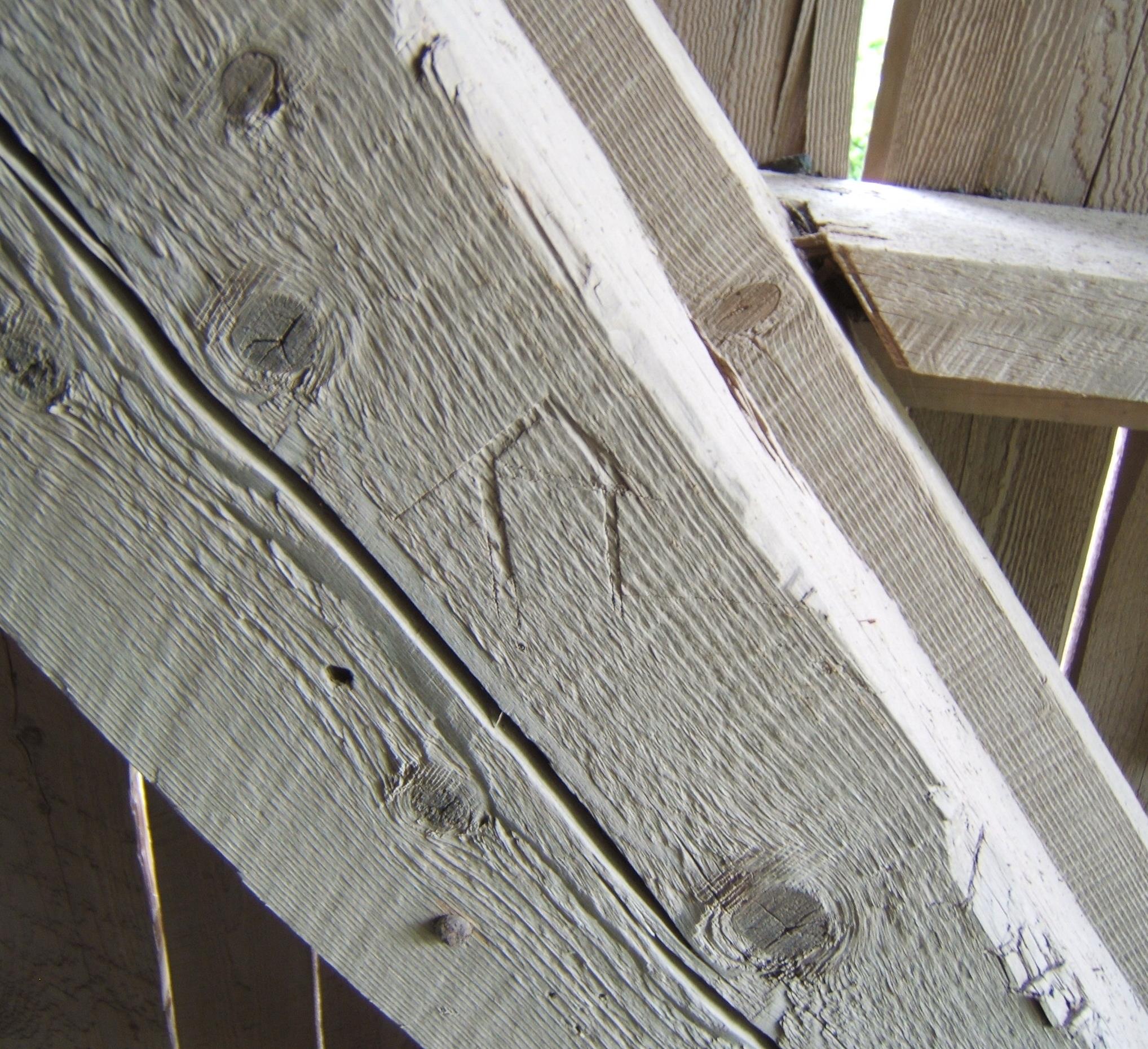
simple carving of a shelter on the Urney Covered Bridge 2015
~
Copyright 2015 Jane Tims
a walk through the covered bridge – disappearing covered bridges
Last week we took a drive to re-visit some of the covered bridges we saw in 1992 as part of a special project to celebrate Canada’s 125th birthday. One of these was the Stone Ridge Covered Bridge (formally known as Keswick River #6), crossing the Keswick River at Upper Stone Ridge in York County. I was looking forward to seeing the bridge because we had recorded some interesting carvings in 1992. Among the usual initials, someone had craved the images of three houses, one with steps and two chimneys, and one, a cottage, on the sill of the bridge window.
A short drive on a pretty country road along the Keswick River brought us to the bridge… a metal Bailey bridge, constructed to cross the river at the point where the covered bridge had once stood. The new bridge was sturdy and had its own charm, but it was so disappointing to know the old covered bridge was gone forever. The Stone Ridge Covered Bridge was lost to fire on October 10, 2008.

The Stone Ridge Covered Bridge was built in 1914 and had a span of 123′ 4″ and a total length of 126′ 4″. It had a roadway width of 14′ 10″ and a capacity of 10 T.
I wrote in our journal, on May 1, 1992: “most carvings were on the flat of the horizontal plate that formed the window sill and ran the length of the bridge”.’ I also wrote: “lots of hacking and hewing done on the window part of the sill”. The oldest date we recorded was ‘May 9, 1951 VHA’.
Some of the other carvings on the bridge in 1992 were: ‘LA + LB’, ‘WLR 54’, ‘VHA MARCH 7, 1952’, ‘1951 [or 1957] MAY 7 WLB [and a small heart]’, ‘KM 1952’, ‘KMB 9/55’, and ‘BB 1951’. There was also a separate carving of an upward arrow beside a ‘B’ and on the next line, ‘KM A4 54’.
I wonder who was VHA and how often did he or she return to the bridge over the years? Who was KM in 1952, and did she return, married, in 1955 with her new last name beginning with ‘B’? Was she married on April 4, 1954 to ‘B’? A mystery, perhaps solvable by looking into some local marriage records?!
It is sad to see the covered bridges in New Brunswick disappear, one at a time. Some are lost due to the dramatic power of the spring freshet. Others are lost to vandalism (fire) – every Hallowe’en residents keep a careful watch on the covered bridge in our community. In 1992 when we did the covered bridge project, our list had 71 covered bridges. The New Brunswick Department of Transportation website http://www.gnb.ca/0113/coveredbridges/coveredbridges-e.asp says there are presently 61 covered bridges in New Brunswick.
~
Copyright Jane Tims 2012
a walk through the covered bridge – Bell Bridge, South Branch of the Oromocto River
Another covered bridge crossing the South Branch of the Oromocto River is the Bell Bridge near Juvenile Settlement, Sunbury County (listed as South Oromocto Rover #3 in the April 1992 pamphlet ‘Covered Bridges in New Brunswick’, no author indicated). This bridge was built in 1931. It is 126′ 4″ long with a span of 123′ 4″. The roadway width is 15′ 5″, and the load limit is 10 t (6 t for double axle vehicles). The maximum clearance is 3.7 meters and a metal height barrier has been installed to ensure trucks exceeding the clearance cannot proceed through the bridge since this can do significant damage to the bridge structure.

The water at this point in the river is shallow and clear. I watched for a long time to see a fish, but they will be hiding in the cooler waters of the deeper pools.


We visited this bridge on April 26, 1992 as part of our Covered Bridge Project for Canada’s 125th anniversary.
In 1992, we found many carved initials inside the bridge, on the various timbers. The oldest date we found was ‘April 3, 1932’. Some of the other initials included ‘LYL May 1, 1932′, RPC [perhaps PRC] June 6 /32’, ‘RS ’77 ‘, ‘ RT MAY 49’, ‘RM AUG 38’, ‘EK’, and ‘AE Mc APR 3/32’. We also found the initials ‘A.K.O.G. APPI 35.’ with the ‘O’ written as a diamond.
On our August drive, I noticed two unrecorded inscriptions: ‘ALIE 69’ and ‘M.O. L R.A.’

I also found a large carved ‘S’, very hard to see…

the ‘S’ is hard to see, just above the knot and about three times the length
Do you suppose ‘M.O.’ still loves ‘R.A.’ ?
~
~
forever
~
we carve our initials
in the beams of the covered bridge
pledge our love to endure
~
but these words may
outlast the love
even the people
~
~
Copyright Jane Tims 2012
a walk through the covered bridge – Smyth Bridge, South Branch of the Oromocto River
On our August drive along the South Branch of the Oromocto River, we crossed two covered bridges. I love these bridges… they are picturesque and so pleasant to walk through. They are also part of the local history of many communities in New Brunswick. I’ve talked a little about covered bridges before in my Blog – please have a look at https://nichepoetryandprose.wordpress.com/2011/09/05/inside-the-covered-bridge/
One of the bridges we saw on this drive was the Smyth Bridge. It crosses the South Branch of the Oromocto River, near Mill Settlement in Sunbury County (listed as South Oromocto Rover #2 in the April 1992 pamphlet ‘Covered Bridges in New Brunswick’, no author indicated).

Inside the bridge, it is cool and dark. When a car drives through, you hug the side, hoping the driver will see you and slow down. I love the sound of the tires on the timbers making up the floor of the bridge.

Down-river, the shallow water of the river glows in the sun. Most of our local rivers are the color of tea, a consequence of their origins in wetland areas.

Up-river of the Smyth Bridge is a gravel beach and water for wading and swimming.

The Smyth Bridge was built in 1912 and has a total length of 139′ 1/2 “, and a span of 136′ 1/2 “. Its roadway width is 14′ 9”. Its Maximum Load is 10 t (6 t for double axle vehicles) and its center clearance height is 3.7 m.
During our Covered Bridge Project for Canada’s 125th anniversary, we visited the Smyth Bridge on April 16, 1992.
In 1992, the oldest dates we could find carved into the bridge were ‘Oct 3, 1915 Sunday’ under the initials ‘R K’ (in pen or pencil) and ‘Feb 1931’ beside the initials ‘LTF’ and ‘LEIK’ to the right of three simple crosses. There was also the totem of a face carved into the south side of the bridge, on the outside corner post. We also found a few other initials, deeply carved: ‘M B’, ‘R H’, ‘C B’, and ‘CED ER May 63’.
Finding these carvings requires patience, a good flashlight and about an hour per bridge, so I didn’t check to see if any of the carvings were still there on our recent visit. Sometimes they are lost when boards are replaced in the bridge during renovations.
I wonder if these people remember leaving their initials in the bridge so long ago?
~
~
‘LEIK’
– initials carved on the boards of the Smyth Covered Bridge, 1931
~
dark
silent
sequestered
~
light leaks between gable
boards, window squares cut high
river water below
sparkles in August sun
~
carved initials announce
the focused presence of
ghosts with knives
~
the clatter of tires
on timbers, as a car
rattles across the bridge
~
~
Copyright Jane Tims 2012
inside the covered bridge
")
the Starkey Bridge over Long Creek
One of New Brunswick’s ‘claims to fame’ is its covered bridges. A covered bridge is a bridge constructed with high sides and a roof, made to cope with winter snow loads. The covered bridge was designed to be easier to cross in winter. Also, these bridges don’t have to be shovelled free of snow after storms.
There are 60 covered bridges in New Brunswick, one less after the Mangrum Bridge, crossing the Becaguimec River, was destroyed by vandals earlier this month. Communities really love their covered bridges and try to keep them safe by holding watches at Halloween and other times of the year. It is a huge disappointment to anticipate driving across a covered bridge you have visited in the past, only to find it has been burnt and replaced with a metal Bailey Bridge.
Visiting covered bridges is a favourite pastime for many New Brunswickers. On a hot day, the bridges are cool inside and there are usually open ‘windows’ to encourage breezes and allow a view of the river. When a car drives through the bridge, the whole structure vibrates and the car tires make a deep-toned rumble. The floor timbers in a covered bridge are pleasant to walk on and the rafters make interesting study for the carvings and writings people have left as mementos of their visits.
In 1992, my husband and son and I began a project to celebrate Canada’s 125thbirthday. We intended to visit all the covered bridges in the province and make a record of the carvings and graffiti inside each bridge.

we promised to include the ‘Canada 125’ logo whenever we reported on our project, so here it is!
We explored many of the bridges, and made pencil rubbings of some of the more memorable carvings. I particularly remember the girl’s name ‘Phoebe’ carved in elegant lettering in the Wheaton Bridge (bridge installed 1916) over the Tantramar River, and a carving of an old car and the date 1910 in the Maxwell Crossing Bridge over the Dennis Stream (bridge installed 1910).

some of the notations in our record for the Maxwell Crossing Bridge over the Dennis Stream
Other markings were also noteworthy. Inside the Falls Brook Bridge at Nortondale over the Nackawic River were the following words in India ink: ‘Ptarmigan Hunter Ray Brown May 12th 1896 Horse had bad leg”. An expert birder in the area told me Ptarmigan have never been recorded in New Brunswick and this could be a valid record.
Another bit of graffiti I particularly liked were the words I AM THE WIND, printed in yellow in at least three of the bridges in Charlotte County, including the covered bridge on Stillwater Road over the Digedeguash River. This bridge is now gone and a Bailey Bridge was in its place the last time we visited.
I am the wind
~
I am the wind
of the Digedeguash
shaped by valley walls
~
I race trout
lift ferns
blow quick kisses
under the wings of butterflies
~
I am the wind
spoken in the beams
of the covered bridge
slipped into space
between
boards
I rattle the roof, the reeds
vibrate with my breath
~
I am the wind
from the County line
to the Passamaquoddy Bay
I race
~
refreshed by the waterfall, salted
by the rising tide
~
carve my name
on the boards, block
my name in yellow
chalk
~
I am the wind
~
Published as: ‘I am the Wind’, Spring 1995, The Cormorant XI (2)
(revised)
© Jane Tims
")
Smyth Bridge, crossing a small tributary of the South Oromocto River


