mudflats and hedgerows
For eight months now, I have been encouraging myself to exercise by pretending to cycle far from home. I use Street View in Google Earth to explore the countryside in parts of the world where I have never been except in imagination. From January 30, 2013 to June 28, 2013, I cycled virtually in Central France, from Lusignan to Ile de Ré. Since July 1, 2013, I have been following the coast in Cornwall, beginning in Rame. In each post, I have presented Street View images I have ‘seen’ along the road. I have also shown you the drawings and watercolours inspired by the images.
~
Change is always refreshing to me, so I am going to alter the way I report my bike trips. In part I am doing this in order to be able to do more posts in my ‘colour of the month’ series and about writing my novel. I might also return to posting some of my poems.
~
In each post, I’ll report on one or more of my days of exercise, and I will show you the drawing or watercolour and the Street View image that inspired the art. I hope you enjoy comparing the ‘real’ image with my artistic interpretation.
~

map showing distance travelled for day 32 to day 34 (map from Google Earth)
~
7-32 Sept. 24, 2013 40 minutes 3.0 km (Portscatho to Bohantha)
~
South of Portscatho, fields are separated by hedges and rows of mature trees. I loved this view of trees against the blue water of the Atlantic …
~

inspiration for ‘row of trees south of Portscatho’ (Image from Street View)
~

September 21, 2013 ‘row of trees south of Portscatho’ Jane Tims
~
7-33 Sept. 28, 2013 35 minutes 3.0 km (Bohantha to St. Mawes)
~
My virtual bike trip on September 28 took me along the Froe River at low tide. The brown mud dominated the scene and reminded me of some of the areas around Moncton, New Brunswick where we have huge differences between high and low tide and spectacular carved mudflats …
~

inspiration for ‘Froe Creek’ (image from Street View)
~

September 19, 2013 ‘Froe Creek’ Jane Tims
~
7-34 September 30, 2013 30 minutes 3.0 km (St. Mawes to St. Just in Roseland)
~
I continue to be enchanted by the way the roadside vegetation is managed in Cornwall. There are strict rules about how and when to trim the vegetation of the verges (the area between the hedge and the road surface) and the hedge. The Cornish roadside hedges are unique in having a ‘stone and turf’ structure. The hedge is basically a stone-faced earth bank, The vertical face of the hedgerow is populated by ferns and flowering plants. On top of the hedge is turf or a shrubby hedgerow. This area is often occupied by oak and other mature tree species.
~
The resulting environment provides habitat for wild life species, including the wild flowers that have been a delight along every bit of my virtual journey. When vines occupy the face of the hedge, it means the hedge has been cut back too severely.
~
For a fascinating read, have a look at the leaflet ‘Cornish Hedge Management For hedges adjacent to highways’ at http://www.cornwall.gov.uk/default.aspx?page=13777
~

inspiration for ‘road near St. Just in Roseland’ Image from Street View)
~

September 26, 2013 ‘road near St. Just in Roseland’ Jane Tims
~
I hope you have enjoyed this part of my virtual journey. Please let me know what you think when you compare my watercolours with the images that inspired them.
~
Copyright 2013 Jane Tims
sea side bright 7-31
~
Portscatho on the Cornwall coast is a village of bright white houses and views of the sea …
~

~
As in most of these seaside villages, there is public access to the shore …
~

~
and a place to stroll along the waterfront and watch the boats at dock …
~

~
If my bike trip was real instead of virtual, I would ask the owners of the patio below if I could sit and watch the ocean for a while …
~
~
Best View: a shed, covered in vines, near Portscatho …
~

September 15, 2013 ‘shed near Portscatho’ Jane Tims
~
Copyright 2013 Jane Tims
the colour of October #1- Virginia Creeper
~
Our Virginia Creeper comes from a shoot I collected along the banks of the St. John River over 30 years ago. It grows on our power pole. Some years it makes great progress and gets to the top of the pole to grow along the wires. Other years it struggles to gain any hold at all after damaging winds, or if the power company decides it needs cutting back. The last few years it has grown into the neighboring bushes. As a result, my lilacs seem to have mutant leaves and turn scarlet when the other lilacs are a sickly yellow.
~
This year the Virginia Creeper leaves are shot with holes from the same insect infestation plaguing them last year.
~

October 7, 2013 ‘Virginia Creeper’ Jane Tims
~
Copyright 2013 Jane Tims
finding places to grow 7-30
~
Stone walls are a common site in the coastal towns and villages of Cornwall. On today’s virtual bike trip, I noticed how plants find growing space in the crannies and crevices of these walls …
~

plants growing in the nooks and crannies of a stone fence (image from Street View)
~
Vines also take advantage of stone surfaces and climb over stone shed and houses until they take the shape of the building they climb on …
~

vines take on the outline of a house (image from Street View)
~
In a maritime climate in particular, lichens often find a place to grow on rooftops or on stone surfaces. Orange-amber lichens have established themselves on the roof and walls of this grand house in Trewithian …
~

amber lichens on stone and roof (image from Street View)
~
Three interesting names today … Treworthal, Treworlas and Trewithian …
~
Best View: shadowed road on the way to Treworthal and a gate near Trewithian …
~

September 14, 2013 ‘road with shadows’ Jane Tims
~

September 14, 2013 ‘afternoon by gate’ Jane Tims
~
Copyright 2013 Jane Tims
small-scale economies 7-29
~
Did you ever sell vegetables by the road or help your kids run a lemonade stand? On Day 29 of my virtual bike trip, I saw two examples of this kind of small-scale economy. Selling roses and pots of plants provides some extra money for the vendor and something pretty or useful to buy along the road …
~

~

map showing distance travelled (map from Google Earth)
~
Setting up a roadside stand means finding a way to display the merchandise (a small bench will do), making a sign on a piece of paper or cardboard, and being ready to run out when you hear a car stop in the yard …
~

selling roses along the road (image from Street View)
~

selling plants along the road (image from Street View)
~
Best View: for some reason cars caught my eye on this virtual bike trip … a green car travelling on a highway near Treworlas and cars with their headlights on as they drove through a dark tunnel of trees near Veryan … I used ‘resist’ to keep the green car white until the last and learned the hard way that too much ‘resist’ will lift the fibres from the paper ! … won’t do that again!!! …
~

September 7, 2013 ‘green car’ Jane Tims
~

September 7, 2013 ‘headlights in dark woods’ Jane Tims
~
Copyright 2013 Jane Tims
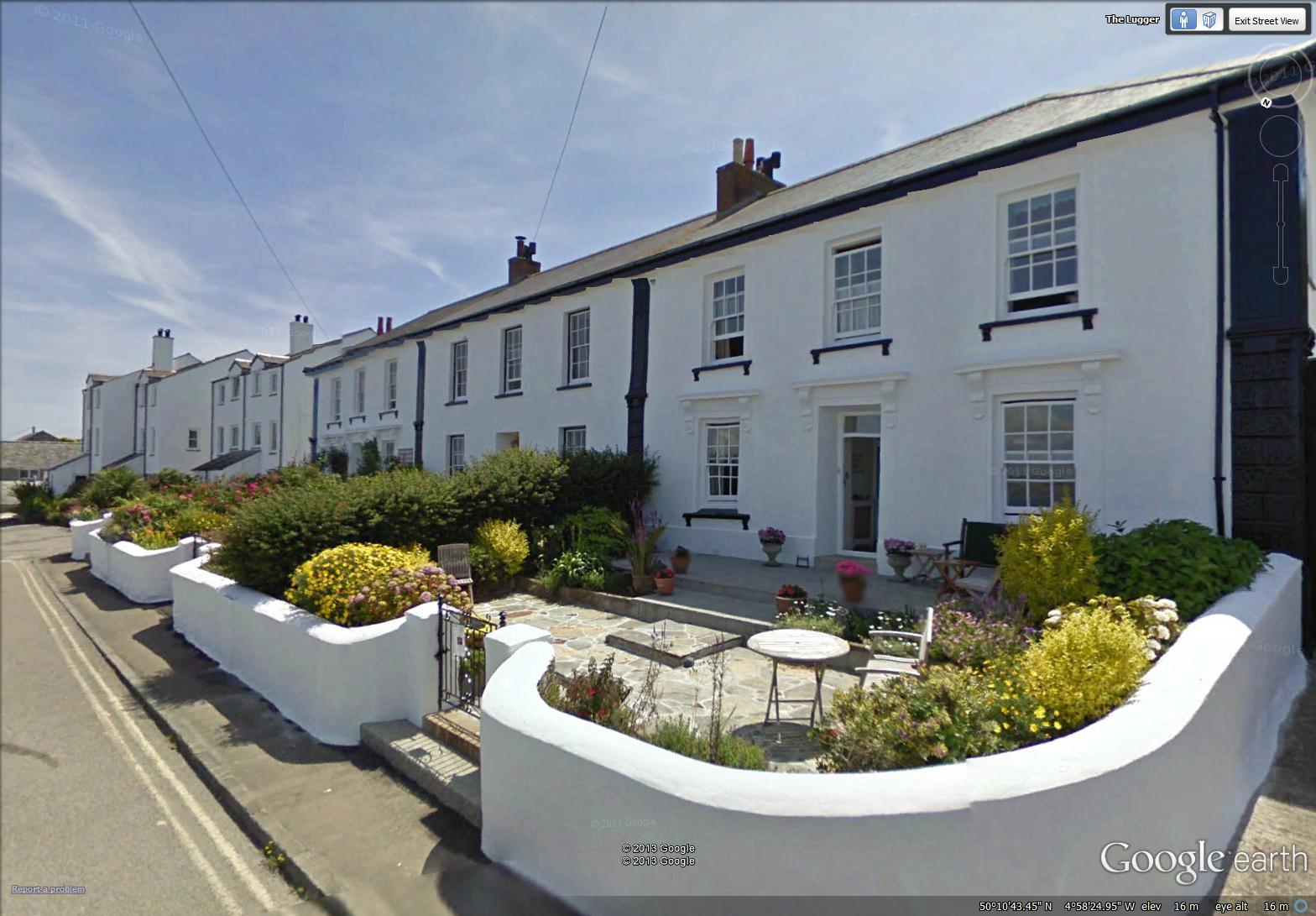
climbing roses 7-28
~
Climbing roses seem to me to be one of the quintessential elements of England. On the 28th day of my virtual bike trip along the Cornwall coast, roses seemed to clamour over every door …
~
~

~
These are a few of the climbing roses of Portloe …
~

~

~

~
Best View: the rugged coast at Portloe … I am trying ‘resist’ to keep small areas white as I paint … you apply the ‘resist’ to the watercolour paper before you begin to paint and then rub it off afterward … worked well, but I have to pay attention to the shape of the small areas of ‘resist’ …
~

September 7, 2013 ‘rugged coast at Portloe’ Jane Tims
~
The ‘resist’ can also be used to leave white space where flowers should be …
~

August 25, 2013 ‘roses in Reviskey’ Jane Tims
~
Copyright 2013 Jane Tims
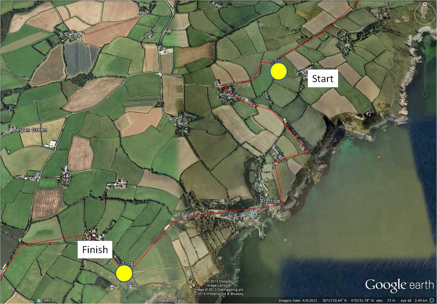
don’t ignore the signs 7-27
~

a view of the coastal path near Portholland (image from Street View)
~

~

map showing distance travelled (map from Google Earth)
~
Today, I cycled very carefully along the roads near Portholland, watching for falling rocks …
~

watch for those rocks! (image from Street View)
~
and falling cars …
~

watch out! danger! (image from Street View)
~
The coast at Portholland is rugged and picturesque, but dangerous for both cars and hikers …
~

those warning signs are important … I think the red box holds equipment for rescue … (image from Street View)
~

more warning signs (image from Street View)
~
Best View: cove at East Portholland
~

August 14, 2013 ‘cove at East Portholland’ Jane Tims
~
Copyright 2013 Jane Tims
the colour of September #5 – red rose hips from pink roses
I have the funniest rose bush in my front yard.
~
It bore double yellow roses for the first few years of its life. Then, in recent years it has become a pink rose, with the frailest pink petals.
~
I know how this happened – not ‘alchemy’ at all, but an example of survival of the fittest. The original yellow rose must have been grafted to the root stock of a common rose. When the yellow rose stem died for some reason, the pink rose stock flourished. I love my frail pink roses , especially at this time of year when they produce bright red, elliptical rose hips.
~

September 22, 2013 ‘red rose hips from pink roses’ Jane Tims
~
Copyright 2013 Jane Tims
along a stream 7-26
~

~

map showing distance travelled (map from Google Earth)
~
One of the difficulties of a virtual trip using Street View is not getting a full view of some of the streams I cross. Until you reach the ‘bridge’, the angle is not right to see the water. When you are on the ‘bridge’, the view is obscured by the blurred curved area in the lower part of the view, a characteristic of the Street View camera.
~
Today, however, I caught several glimpses of a stream that followed the road from Manassick Wood to Portholland …
~

stream along the road near Manassick Wood (image from Street View)
~
I even had a glimpse of a small waterfall created by a tributary to the stream …
~

course of a waterfall … almost dry in this image, but during and after a rain, it must be lovely (image from Street View)
~
The best look I had at the stream was after it emerged from the woods to a field of white flowers. The flowers look a little like Queen Anne’s Lace (Daucus carota), with white, umbrella-shaped flower clusters. However, these plants look more robust than the rather delicate-looking Queen Anne’s Lace, so I will just call them a species of wild parsnip.
~

stream banked by white flowers (image from Street View)
~
Best View: ‘biking’ from the woods into the bright sunshine and seeing the stream meandering toward the sea, banks overflowing with white flowers …
~
' Jane Tims")
August 25, 2013 ‘valley to the sea (Portholland)’ Jane Tims
~
This is the view that inspired the painting …
~

valley with stream and white flowers, looking towards Portholland (image from Street View)
~
Copyright 2013 Jane Tims
naming the woods 7-25
~

~

~
Today’s bike trip took me past the ‘woods’. Almost any time I ‘bike’ through a wooded area in Cornwall, I find the wood has a name on the map. I think naming the various acreages of woodland makes them more precious. Giving a name to the woodland identifies it and acknowledges its right to exist.
~
The names of the woodlands in the Caerhays area of Cornwall include: the Forty Acre Wood (reminds me of Winnie the Pooh!); Castle Wood; Kennel Close Wood; and Battery Walk Wood, among others. Each woodland has its own characteristics and I long to get off my virtual bike and explore some of the woodland plants.
~

on the right is the Forty Acre Wood (image from Street View)
~
I know from my history studies that forests and woodlands are strongly connected to the history of England. The nobility of post-Conquest England had a special love for the forest and the hunt, and protected park-like settings for the pursuit of wild game.
~
In the 12th century, the king protected the woodlands with the Assizes. These were formal rules governing both the public and officials. The purpose of the “Assize of the Forest” was to protect the forest and the game living there. The Assize described rules for conduct in the forest and for use of the land, wood and game. It also described the roles and responsibilities of those assigned to protect the forest, enforce the laws, and monitor and report on the state of the forest. The Assize further specified punishments for breaking the rules and for the forest administrators if they failed to meet their responsibilities.
~

road through Kennel Close Wood (image from Street View)
~
The rules of the Assize were designed to ensure the continued use of the forest.
For the King, one value of the forest was as a source of revenue from rents and fines. Rental income came from pannage (keeping of swine) and agist (pasturing). Fines were generated from illegal hunting and other uses, purprestures (encroachment such as building within the forest), and assarts (use of the forest clearings). Wood had value as fuel, or as timber for building boats, bridges, defenses and castles. Other values included the King’s own pleasure in hunting, and the favor he gained from gifts of venison or other wild game, or from granting others the privilege of hunting.
~

the secluded and cloistered Battery Walk Wood (image from Street View)
~
Medieval hunters had various words to describe the different parts of the woodlands. The ‘chase’, for example, referred to the open woods for hunting of deer, and the ‘warren’ described the unenclosed tracts where other wild game such as pheasant and partridge were hunted.
~

three deer among tamarack in New Brunswick
~
Best View: shadows on the road … hill on one side and the Forty Acre Wood on the other …
~
' Jane Tims")
Sept 6, 2013 ‘shadows on the road (near Gorran)’ Jane Tims
~
Copyright 2013 Jane Tims


