Archive for the ‘virtual cycling along the Baie-des-Chaleurs in New Brunswick’ Category
a close look at the landscape (day 4)
On day 4 of my virtual travels in northern New Brunswick, I continued to follow the Restigouche River …
~

~
8-4 January 11, 2014 30 minutes 3.0 km (McLeods to Maple Green)
~
I love the topography of the area. As I’ve said before, the mountains here are part of the northern Appalachians. These mountains were created about 480 million years ago and were gradually eroded to a flat plain. Then, upheaval of the earth’s crust gave us the undulating hills and mountains we see today.
~
Today on my virtual bike trip, I could see one of these features, a low dark hill on the right of the horizon.
~
mountain along the highway near Maple Green (image from Street View)
~
I think it is interesting to look for these elements of landscape on the satellite map – I found this feature easily, a dark curved escarpment, just south of Maple Green. It is a ‘mountain’ caught between the water of Porcupine Brook (flowing out of Hicks Lake) and the deposits of the Restigouche River …
~

labelled satellite image (image from Google Earth)
~
You can also look at the mountain in the ‘ground-level view’ of Google Earth. I don’t know how this ‘mountain’ was formed, but a geologist could likely tell an interesting story of its history …
~

the ‘mountain’ is in the upper right hand corner (image from Google Earth)
~
A look at the view above shows how different land owners have taken different approaches to managing their woodlands (the tan-coloured band is a strip of clear-cut forest). The property boundaries, of course, pay little attention to geology, so there are several landowners on the ‘mountain’.
~
In one respect, the property boundaries do pay attention to the landscape. As in other areas along rivers or the coast, properties were historically arranged so each land owners had access to the waterway. You can see this on the satellite image …
~

properties along the river – every owner originally had some access to the river (image from Street View)
~
and also on an old property map of the area …
~

old property map of area around Maple Green (Source: Provincial Archives of New Brunswick)
~
Sometimes, to get access to property by the river, people need long driveways. Sometimes the road has to cross the railroad …
~

January 12, 2014 ‘railroad crossing’ Jane Tims
~
Copyright 2014 Jane Tims
trees and more trees (day 3)
Once I was asked to conduct a bus tour of southern New Brunswick for some visiting city administrators. I prepared well for the tour and had lots to show and tell them. I got a laugh for beginning my tour with: ” There’s a tree and there’s a tree and there’s a tree…. ” All joking aside, New Brunswick has a lot of trees. A drive almost anywhere means driving through many kilometers of forest or woods.
~

map showing distance travelled (map from Google Earth)
~
8-3 January 7, 2014 30 minutes 3.0 km (south of McLeods to McLeods)
~
On the third day of my virtual cycling trip in northern New Brunswick, I took a few backroads and, you guessed it – saw lots of trees. Well I love trees, so that may be one reason New Brunswick, in my opinion, is a great place to call home.
For the most part, we have a mixed wood composition to our forests – both hardwood and softwood. One thing I’ve noticed in painting my first watercolours of New Brunswick is the dark blue tinge to hills on the horizon. I think this is due to the large number of conifers (White, Black and Red Spruce, Balsam Fir and White Pine, among other species).
~

January 8, 2014 ‘Route 280 near Dundee’ Jane Tims
~
Painting trees is a challenge for me. My biggest problem is ‘green’ … I use Sap Green and Oxide of Chromium, and mix these with blue and yellow, but I can never seen to capture the emeralds of nature!
~
Copyright 2014 Jane Tims
along the river (day 2)
For many days of my virtual travel during Phase 8, I will be ‘biking’ along the north shore of New Brunswick. At first, I will travel along the Restigouche River. Then I will continue as the river opens into the Baie-des-Chaleurs. Just across the water will be the distant hills of the Gaspé Peninsula of the Province of Quebec.
~

~
map showing distance travelled (map from Google Earth)
~
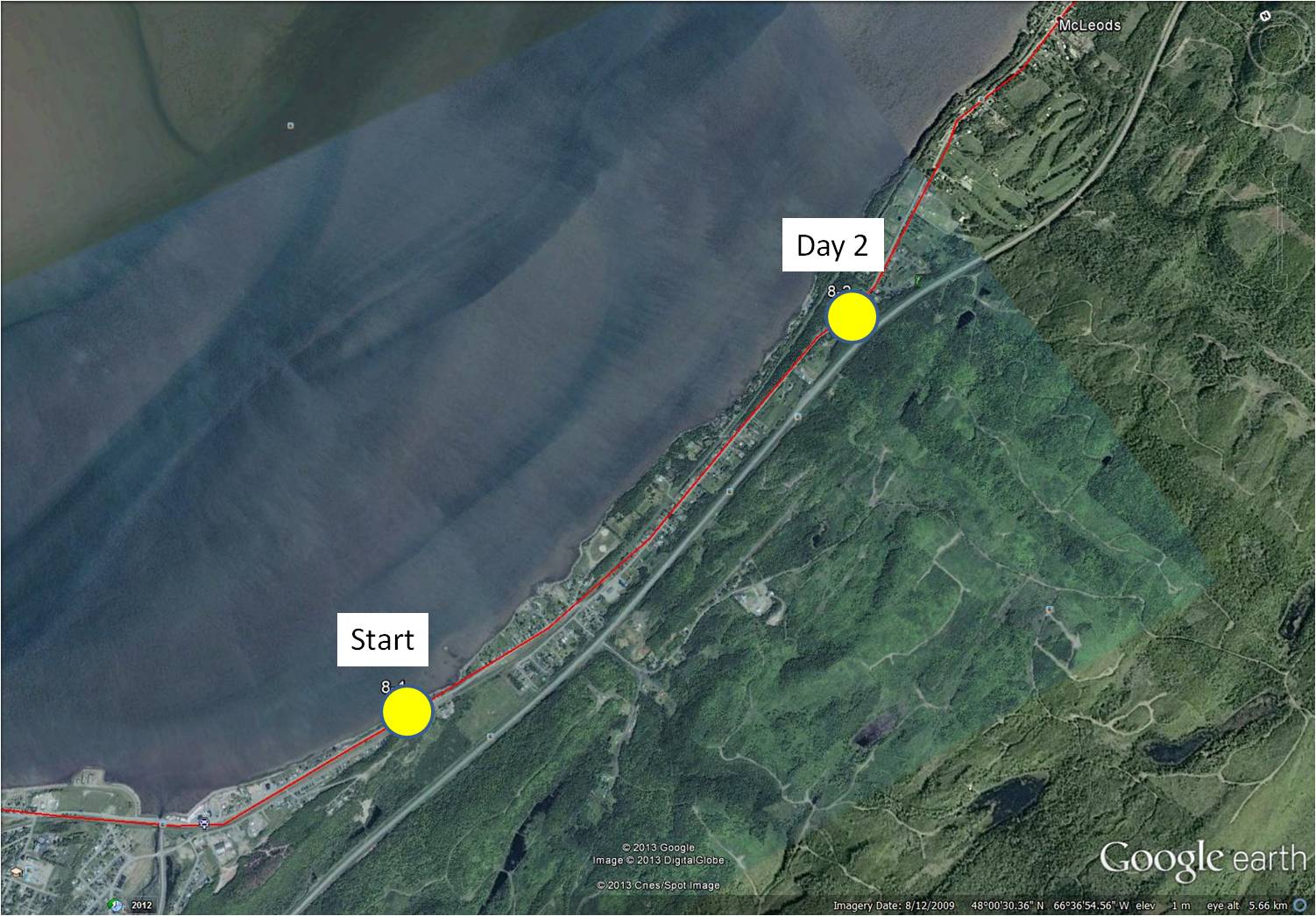
8-2 January 5, 2014 35 minutes 3.0 km (Richardsville to south of McLeods)
~
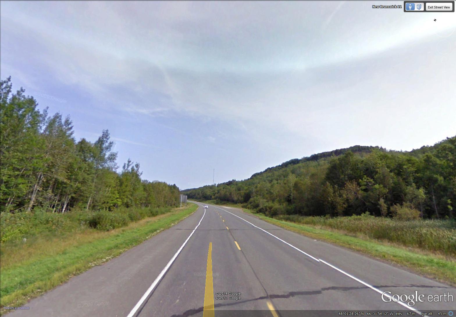
On day 2 of my travels, I followed the relatively straight road along the coast. The houses in rural New Brunswick are usually arranged in small communities with houses in a linear pattern along the main road. New Brunswick has a lot of Crown Land (about 48% of the area), arranged in large blocks. As a result, communities (and the associated privately-owned land) are often separated by long stretches of largely forested Crown Land. Crown Lands are not privately owned but are managed by Federal or Provincial Departments for the people of the Province.
~

a typical stretch of road along the north shore (image from Street View)
~
Most of the communities along the northern shore of New Brunswick are French-speaking, so when I see people along the road, I will be able to practice my French, as I did in France.
~

January 7, 2014 ‘Restigouche River and the hills of Gaspe’ Jane Tims
~
Have you ever travelled in New Brunswick? If so, I hope you enjoyed your stay!
~
Copyright 2014 Jane Tims
a leaping salmon and a mountain (day 1)
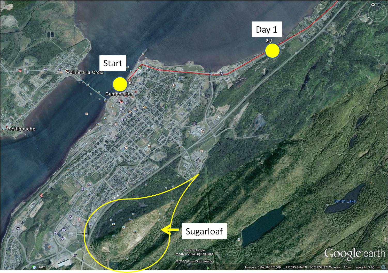
On December 31, 2013, I started on Phase 8 of my virtual cycling program. In this Phase, I am going to ‘travel’ on my stationary cycle along the north shore of my own Province, New Brunswick. I decided to start in the City of Campbellton because I have so many pleasant memories of working and vacationing in that area. Most of the roads I am ‘cycling’ in Street View, I have driven in reality, so most scenes are familiar.
~
8-1 December 31, 2013 35 minutes 3.0 km (Campbellton to Richardsville)
~
I began at a familiar landmark in the Campbellton area, the statue of the leaping salmon. The Restigouche River is world famous for its Atlantic Salmon population so the salmon is a fitting symbol for the area. In 1999 when my husband, son and I vacationed in the Gaspé of Quebec, we stopped here for a photo before leaving New Brunswick.
~
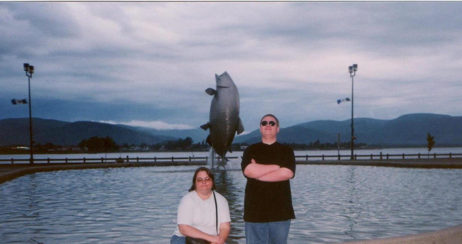
my son and I in front of the leaping salmon in 1999
~

start of my 2014 virtual cycling trip (image from Street View)
~
Across the street from the leaping salmon (and visible in the photo of my son and me) are the waters of the Restigouche River and the distant hills of the Gaspé. Since these will be with me for the first few days of my virtual adventure, I took a side trip a few kilometers inland for the subject of my first watercolour – Sugarloaf Mountain.
~
Sugarloaf is 281.1 meters in height, a part of the Appalachian Mountains and of volcanic origin. The mountain is within the City limits of Campbellton and is the location of Sugarloaf Provincial Park. Sugarloaf is the site of a ski resort, hiking and cross-country ski trails and a system of mountain biking trails.
~
In the late 1970’s and early 1980’s I climbed Sugarloaf a few times, gathering plants for air quality studies. I’ll talk more about those hikes as I proceed on my virtual trip since I have many memories of working in the area.
~

December 31, 2013 ‘Sugarloaf, New Brunswick’ Jane Tims
~
~
Although I enjoyed my virtual cycling in France and England, I find I have a more accurate perspective and sense of scale as I travel in New Brunswick. I am looking forward to showing you some of the beautiful scenery along the Restigouche River and la Baie-des-Chaleurs!
~
Copyright 2014 Jane Tims


