Posts Tagged ‘history’
garden escapes: lost settlements
During my project about garden escapes, I have discovered just how many settlements and properties have been lost from the New Brunswick countryside. The loss has been due to struggles which are largely rural at their roots: struggles due to economics, disease, the hardships of winter, the lure of the city.
~
Loss of these communities and houses has an impact on us all. The value of rural community has been pointed out recently by the COVID-19 pandemic. One of the reasons we have done relatively well in New Brunswick is our rural nature and the low population density.
~
To me, the sad side of the loss of rural community is the loss of information about these places, what it was like to live there and who the people were. What did they think about. Who did they love? What were their struggles?
~
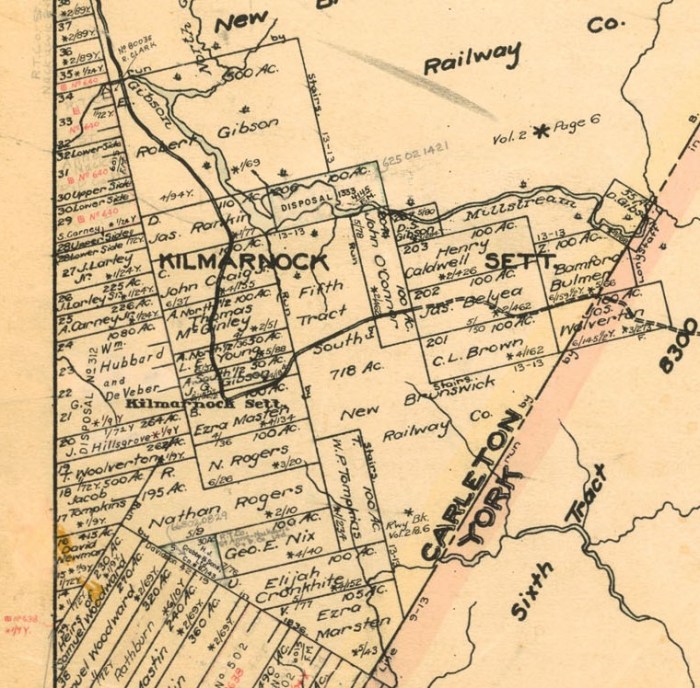
The information can be knit together by a painstaking process of gathering the available puzzle bits and pulling the clues together. To illustrate, I will use the example of Kilmarnock, an abandoned community near Woodstock.
~
Today, Kilmarnock is a long drive on a backwoods road. There are lots of camps along the road and the road itself is kept in good condition.
~

the Kilmarnock Settlement Road
~
First, there is no one place to go to for all of the information on a community. In New Brunswick, we do have a wonderful New Brunswick Archives website called Where is Home? https://archives.gnb.ca/Exhibits/Communities/Details.aspx?culture=en-CA&community=1963
The database for the settlement of Kilmarnock is short, typical of many communities listed.
William Gibson, who immigrated from Kilmarnock, Scotland, settled here in 1843: in 1866 Kilmarnock was a small farming settlement with about 3 families.
Among other information is a cadastral map of land grants, a bit mind-numbing because it shows a map of all grants, regardless of date.
~
~
Another source of information is the Canada Census. In Canada, the Census is available for the first year of every decade. I access the Census through my membership with Ancestry.ca and by knowing a name and the approximate birth year, I can usually find a lot of information on a community. In this case, I know the parish where the Census was taken (Northampton Parish, Carleton County) and I have the information from the Where is Home? site.
~
Because the settlement was established in 1843, I looked at the Census for 1851, knowing that some changes will have occurred in the interim 8 years. I find William Gibson and his family right away.
~

~
Name and Age
William Gibson 63
Robert Gibson 87
Jane Gibson 60
David Gibson 23
Wallace Gibson 21
Elizabeth Gibson 18
Bruce Gibson 15
~
Some of the notes about the family tell me that Robert and Jane were the married couple, not William and Jane, even though they were of an age. The Census also says that Robert and Jane had been in Canada since 1820 and that Robert was William’s uncle. Other notes say that William, Robert and Jane were from Scotland and William was a millright.
~
So, is this the William Gibson who founded the community? I think so. The ‘millright’ occupation is interesting since it explains the name of the stream, Gibson Millstream.
~

Gibson Millstream, looking east
~
Although the database says there were only three families in the settlement in 1866, the 1851 Census tells a different story. If you look for the names on the cadastral map, you can find most of them in 1851, on the pages before or after the notations for the Gibson family. The Census shows there were at least nine families in Kilmarnock in 1851. Starting from the crossing of the stream and working southward:
- Robert and Jane Gibson and family of 7, including uncle William Gibson, age 63
- James and Marrion Rankin and family of 7
- Robert and Mary Craig and family of 1
- Thomas and Nancy McGinley and family of 7, including the grandfather Joel Young, age 82
- John and Elizabeth Gibson and family of 4
- John and Thankful Marsden and family of 6
- Peter and Nancy Marsden and family of 5
- William and Bathsheba Tompkins and family of 10
- Joseph and Margaret Wolverton and family of 3
~
If you look at the cadastral map above, these names match the surnames of property owners on the map, reading from north to south and then from west to east.
~

~
A look at the Census for 1881 is also interesting. All of these families and others are represented, although some people have died in the thirty years, and some families have grown.
~
With regard to the garden escapes project, my discoveries were few. We did not see the south part of Kilmarnock settlement because of a cable across the road. However, the Google Earth satellite map shows that fields have been used and there is a windrow of trees between two adjacent fields (probably between the McGinley and Young properties).
~
The only other vegetation sign we saw was an old apple tree on the corner where the road crosses the Gibson Millstream (marked with an ‘x’) and a young apple tree along the road (also marked). Perhaps these trees are descendants of settlement times, perhaps they are apples from a wandering deer up for a visit from Woodstock.
~

apple tree at Gibson Millstream crossing
~
So much knowledge is lost from generation to generation. I find it a good argument for telling stories, keeping diaries, writing letters, keeping blogs, contributing to community endeavours.
~
One of the poems in the project will be the imagined walk along the Kilmarnock Road by Mary Craig and her son John, 2 years old.
~
This work is accomplished as part of an artsnb Creations Grant.
~
Get out your diary and write in it. Sort your photos.
So much to do.
If you don’t want a future poet making up stuff about you.
All my best.
Jane
root cellar

~
root cellar
~
over the hill
cold earth sequesters
seeps of water
and lichened stone
roots in dry sand
preserves on shelves
of rough-hewn boards
~
mice gnaw on the seam
of a gunny sack of corn
blue mold on the surface
of a jar of apple jelly
Mama just scoops it away
pumpkins never keep
past December
~
~
Copyright Jane Tims 2019
~
All my best,
Jane
next Authors Coffee House
Interested in history? The next reader in the Authors Coffee House series will be Dr Ross Hebb who will read from his books about Maritimers in World War I, ‘In Their Own Words’! Reading is next week on Thursday March 21st at noon and a hot lunch will be served. Hope to see you there!

celebration of a covered bridge 2
Last Saturday, about thirty people gathered in the Rusagonis Covered Bridge Park to celebrate our beautiful covered bridge (the Patrick Owens Bridge) with readings and stories.
~

~
We heard from several speakers and readers including:
~
Jeff Carr … Jeff is MLA for New Maryland-Sunbury and candidate for the Progressive Conservative Party in the upcoming provincial election. He recalled the loss this year of the Bell Covered Bridge and some of the frustrating circumstances around that loss.

~
Linda Cogswell … Linda is a local historian and reminded us of the history of the Patrick Owens Bridge and the celebration a few years ago of its first hundred years! The original cost of the Patrick Owens Bridge in 1908 was $5,439 !

~
Rose Burke … Rose’s reading recalled the loss of the Upper Mills Bridge to fire in 1956 and what it was like to live in a border town in the 1950s. Kids would travel freely across the border, back and forth from Baring, Maine to Upper Mills, New Brunswick, to buy ice-cream or play at one-another’s houses!

~
Jenica Atwin … Jenica, a long-time resident of Rusagonis and candidate for the NB Green Party in the upcoming provincial election, read a poem about the way covered bridges affect our daily lives.

~
Roger Moore … Roger gave a poignant reading of his poems about our recent flooding in the area and recalled eerie battles with rising water and ruined belongings.

~
Neil Sampson … Neil read a poem about the Bell Bridge by Fredericton’s Cultural Laureate, Ian LeTourneau. He also read his own humorous poem about attending a covered bridge gathering after a dental appointment (with ‘covered bridges’).

~
and me (Jane Tims) … I read from my poetry book ‘in the shelter of the covered bridge’. The book includes several poems about the Patrick Owens Bridge and the wild life encountered there – deer and groundhogs, blue jays and rabbits.

~
Ray Boucher, President of the New Brunswick Covered Bridge Conservation Association, was on hand to chat about the goal of protecting our remaining covered bridges and ask people to sign the petition to ask government to take steps to preserve the bridges.

~
The park was perfect for the occasion and many folks said we should continue to use the park for community events.

~
A big thanks to Jeff Carr and his team of Kim Smith, Pat and Mac Burns, Bernie Phillips and others who prepared some delicious food for everyone.
~
The day was hot and breezy and all those hats were needed in the afternoon sun!!!

~
All my best!
Jane
Forty Five River Covered Bridge
On our drive to see New Ireland (Albert County), we took the Collier Mountain Road to the south at Teahan’s Corner to see the Forty Five River Covered Bridge. Exciting to see a covered bridge I had never seen before!
~

approach to the Forty Five River Bridge
~
Forty Five River is so-named because it took 45 minutes to raft logs from New Ireland down to Alma (Source: http://newirelandnb.ca/communities-the-irish-of-albert-co/ ).
~

the Forty Five River, looking south
~
Where the covered bridge crosses Forty Mile River there is a steep gorge and the winds were howling when we visited the bridge.
~

~
Although the road is rough traveling, the Forty Five River Bridge is in excellent shape, showing new timbers throughout. It was pleasant to sit on the bench-like side timbers and listen to the wind.
~

~
As with most bridges in New Brunswick, the bridge has a social history, partly engraved in its beams.
~

~
For more information on covered bridges in New Brunswick, click on the Categories tab at the right, under ‘covered bridges‘.
~
All my best,
Jane
Bell Bridge
Over the past weekend, we were inundated by heavy rains and a sudden rise in temperature. The resulting meltwater and rainwater combined to cause flooding in much of the province. There has been lots of damage to homes and roads and other infrastructure.
~
One of the casualties is the Bell Covered Bridge, also known as South Oromocto River #3. Although its ultimate fate is unknown, the damage will be assessed and perhaps we will lose yet another of the 59 covered bridges remaining in the province. I am not alone in hoping this bridge can be repaired or preserved in some way as a reminder of our history and the importance of these bridges to our communities and our heritage.
~

~
Copyright Jane Tims 2018
New Brunswick’s covered bridges … kissing bridges

~
A covered bridge is also known as a ‘kissing bridge’ – a place where a couple can steal a caress in privacy. A covered bridge has always been a good place to leave a message about affection for one another.
~
During our covered bridge visits, we’ve seen lots of examples of these messages …
~
At least two notations of love in the MacFarlane Covered Bridge (Ward’s Creek #2) …
~
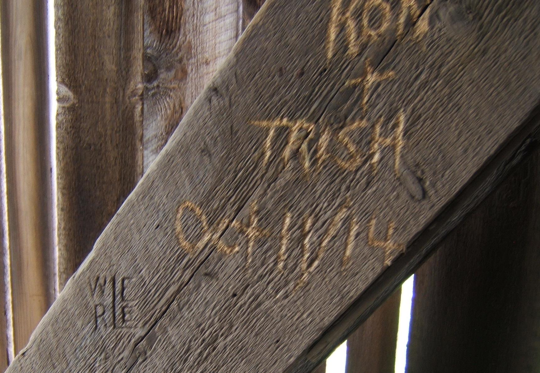
Ron and Trish, 2014 and WR and EE, years ago … MacFarlane Bridge
~
And another way of linking two sets of initials in the Marven Bridge (Belleisle Creek #2) …
~

A heart links J G and CW on the Marven Bridge
~
‘Just Married’ in chalk in the Moores Mills Bridge (Trout Creek #5) …
~
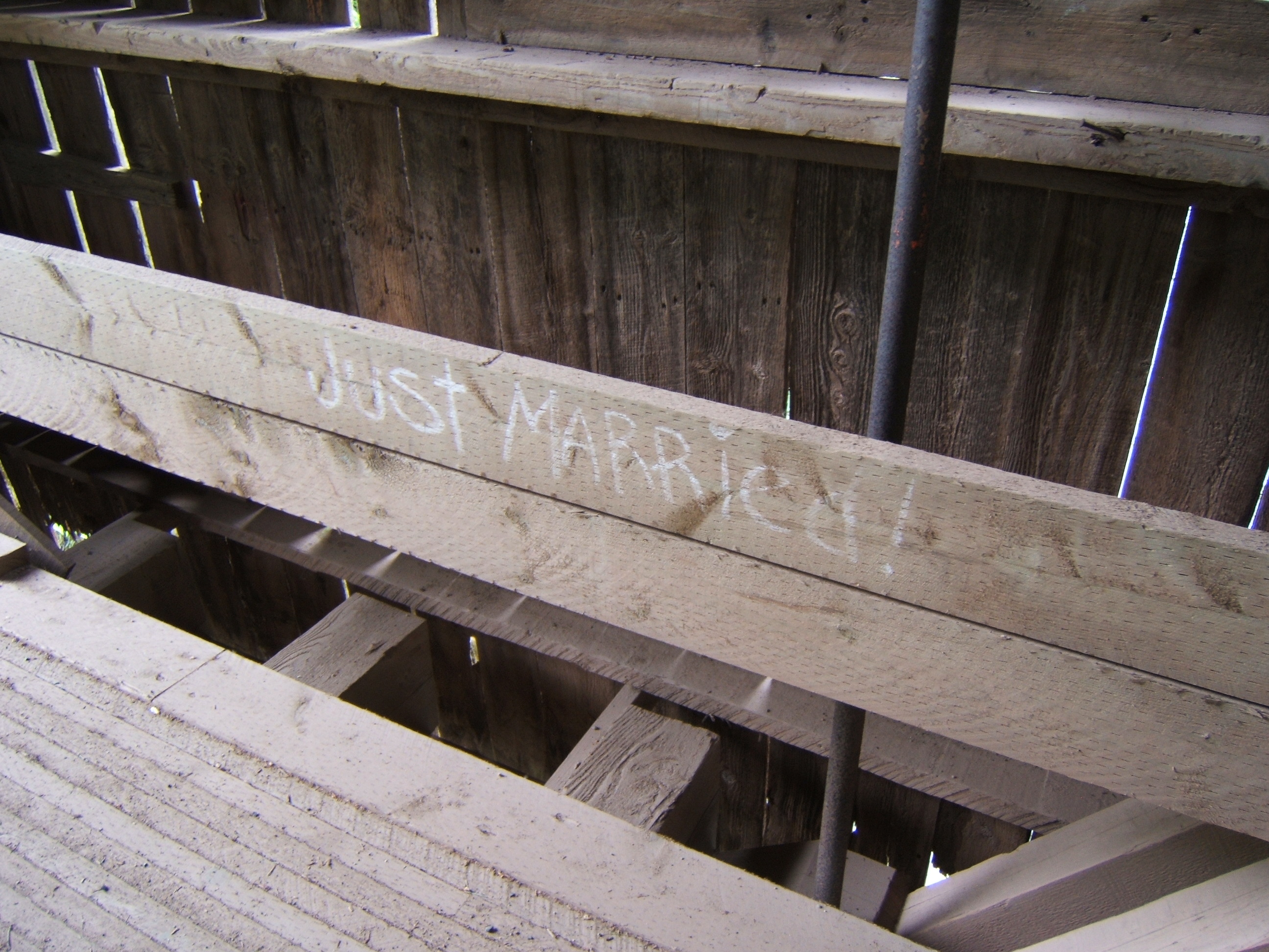
a chalk message in the Moores Mills Covered Bridge
~
And, back in the MacFarlane Bridge, an incomplete notation. Who did LANA love?
~

LANA + in the MacFarlane Covered Bridge 2015
~
Copyright 2017 Jane Tims
in the shelter of the covered bridge – Plumweseep Bridge, New Brunswick
Plumweseep Bridge (Kennebecasis River #9) built 1911, not far from Sussex …
~

~

~
The covered bridge in its setting … surrounded by trees, river running beneath, a field of ripened grain in the foreground, the rolling hills of the Kennebecasis Valley in the background.
~
~
Copyright 2016 Jane Tims
last days of a covered bridge … French Village Bridge
More sad news for New Brunswick’s covered bridge heritage … In the past months there has been lots of discussion about the fate of the French Village Bridge, also known as Hammond River #2, near Quispamsis, Kings County.
~
Built in 1912, the French Village Bridge is one of only 60 covered bridges remaining in the province. In October, 2016, the bridge was severely damaged when a loaded excavator broke through the decking and undercarriage of the bridge. Although the government began repairs, rot was discovered in the sub-structure. After holding public meetings to consider options, the government recently announced the bridge would be demolished and a modular bridge would take its place.
~
The covered bridge is endangered in New Brunswick. In 1900, there were about 400 covered bridges in the province. By 1944, there were only 320. In 1992, when we visited some of the bridges for Canada’s 125th birthday, there were 71. In 2017, as I write this, there are only 60 remaining. Loss of the French Village Bridge will bring the number to 59. Vandalism, flood, accident, fire and age claim more bridges every few years.
~

~
The French Village Bridge is one of those included as subject matter for my upcoming poetry book in the shelter of the covered bridge. As a result, it is one of the bridges we visited to gather information on the plants and animals found there. We are also interested in the human history of the bridge, so we took photos of the carvings inside.


~
When I look at the small amount of information I have on this bridge, I am saddened and angered to know how much will be lost. Although economic considerations are important, the loss of built heritage includes loss of community character and part of our material culture. When ‘ROGER’ and ‘B’ and ‘E’ carved their names into the beams of the bridge, they probably thought the bridge would last many years into the future.
https://janetims.com/2016/05/16/a-drawing-of-a-covered-bridge/
~

~
Copyright Jane Tims 2017
changing communities
Last week we went for a drive to the Cornhill Nursery in Kings County to buy a new cherry tree for our yard. Afterwards we took a drive to visit some of the old communities in the area. One of these communities, Whites Mountain, was a rural farming community with 17 families in 1866 (New Brunswick Provincial Archives). By 1898 the community had one post office, one church and 100 people. Today the community consists of a few farms and residences, perched on a steep hillside overlooking the hilly landscape of northern Kings County.
~

On the road descending Whites Mountain, Kings County, overlooking the broad Kennebecasis Valley (September 2016)
~
One of the most interesting sights on our drive may also be evidence of the farmsteads formerly in the area. Although Virginia creeper (Parthenocissus quinquefolia (L.) Planch.) is native to North America, in this area it is usually associated with human habitation. In the thick woods north of the community, we found Virginia Creeper in profusion, covering the surface of the trees.
~

~

~
Although there is only forest here now, perhaps the ancestors of these vines covered barns and other buildings in the area.
~
Copyright 2016 Jane Tims


