Posts Tagged ‘GIMP’
next book in the Meniscus Series: the maps
One day in 2016, when I was first deciding how I would put the Meniscus books together, I puzzled over how I would make the maps I wanted to include in each book.
~
At first, I wanted to produce hand-drawn maps, re-drawing each map and making erasures and changes as each book advanced the story. Every book would need adjustments to the map and a new dotted ‘trail’ to show the path my characters followed.
~
The idea of hand-drawn maps ended when I found out how boring it would be to draw the 300 trees in the Themble Wood.
~
I didn’t know a thing about digital image creation. So I went on line and found GIMP, the GNU Image Manipulation Program … what a great place to learn the craft of making maps! https://www.gimp.org/
~
Now, four years later, I have not needed to move from GIMP. First I learned how to make trees …. in quantity and with shadows! There are three kinds of tree on Meniscus: grammid, yarnel and banyan:


~
Once I had trees all across my maps, I added the geological features I knew were essential for world-building: in the first book of the Meniscus Series I wanted (left to right) a gully, a line of huge burrows, a fault (and high associated cliff), a hill and a large water feature (a churn).

~
I also knew I wanted towns and cities, as well as the roads between them:

~
I also add trails to show where my characters travel during the book.
~
GIMP has met every need. And my maps can change with time; all I do is turn various layers on and off, creating new combinations of features and paths.
~
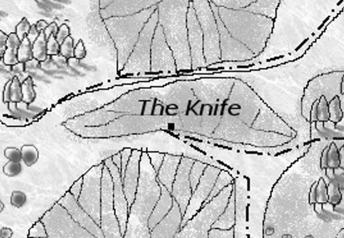
Here is one of the maps for my next book Meniscus: The Knife:

The dotted line (– . — . — . –) shows Tagret’s path as she goes on her quest to rescue Rist.
~
All my best,
staying home and in my two-family bubble,
Jane
a map to go with a story
Since I began to read, I have loved to have a map included in the book – the more detailed the better!
~
The maps that come to mind include the five maps of Middle Earth and the detailed map of the Shire in J. R. R. Tolkien’s The Lord of The Rings (Methuen Publications), the maps of Great Britain and Wales inside the front cover of Mary Stewart’s Crystal Cave (William Morrow and Company, Inc.), and the map of Martha’s Vineyard accompanying all of the books in Philip R. Craig’s Martha’s Vineyard Mysteries (Scribner). Although books in the mystery and fantasy genres often have maps, almost any book can include a guide to the geography of the book.
~

the completed GIMP map for Meniscus: South from Sintha … every feature has its own layer so I can add a tree, delete a path, or add a house to a village!
~
When I began my Meniscus series, I knew a map was needed. I needed it, to help me plot the story and action!
~
At first I thought I would do a hand-drawn map and make changes as needed. Foolish girl! I would have been drawing maps forever. I have included a new map with each book, showing the path taken by the characters and any new features they find in the landscape. Fortunately I chose GIMP (GNU Image Manipulation Program), a free on-line app similar to Photoshop Pro. I had never worked with GIMP before, so I took the time to learn the system and I still have trouble with those ‘paths’. The system produces maps in layers. I can have a map for each kind of tree in the forest, a map for the grasslands, one for the villages and cities and so on.
~
This week I started plotting for the seventh book in the series (two are now published and the third is expected out next week). I have told all the stories I care to (for now) for the first map (Map of Prell-nan South District, Meniscus), so I have been working on the landscape of Prell-nan North District.
~
I first designed this map at the laundromat. Laundromats are the best place to read and write and think. No one bothers you and there is a set time to work. Many of the details of the map will change but it shows the basics of the portion of planet Meniscus I am building.
~

a very draft map of Prell-nan North District, Meniscus … the features on this map will be continuous with the map of the South District … the original map is 4″ by 3″ … I drew on what I could find!
~
I have now finished most of the layers on GIMP. I still need to label the various features and tidy up some of the layers. Now I can use the map to help me plot the journey of my characters and their actions!
~

the first draft of the map on GIMP … I love creating all those little trees!
~
Be watching for the next book in the Meniscus series! Meniscus: Winter by the Water-climb tells the continuing story of Odymn and the Slain, and gets them through a brutal winter on planet Meniscus! Their love story and adventures continue with some new characters.
~
Copyright 2017 Jane Tims
learning curves
In the last two weeks, I’ve taken a detour. Instead of working on my poetry or novels, I’ve had some fun creating a fantasy tale. The story is about a young woman who tries to escape servitude only to find herself back in a similar situation. The story takes place in the future, on a planet far from earth.
~

~
Writing the tale was fun. Creating a simple language to use in the dialogue was interesting. Finding some names for the characters and places was a challenge but very satisfying.
~
Making a map to describe the setting was no fun at all. I liked creating the spaces, thinking about where to put the landscape features and towns. But, I had to make a decision:
- draw the map by hand and risk wanting to change names or details in the future, or
- create the map in a layered digital format where I could make changes anytime I want
~
I decided to do the map in GIMP (GNU Image Manipulation Program), a free on-line app similar to Photoshop Pro. I have never worked with GIMP before, so I have had some frustrating hours coming up the learning curve. But, I have prevailed and I now have a map to suit my story.
~

a map to go with the story
~
The story is told in poetry and is based on a world where water doesn’t behave as it does here on Earth. Instead it effervesces and tries to flow upward. Hence a water-climb rather than a water-fall. This is just a taste of the story. The main characters are fleeing, pursued by an alien species, the Gel-heads (Gel-heads have transparent skin, like green gelatin). Windfleers are flocking birds, like large white starlings.
Terrain changes. A climb, the way rocky, tangled.
Glimpses of a water-climb.
Shouts in the valley behind them, Gel-heads
sensing the prey is near. Need for stealth and speed.
Burst from the forest to a plateau. The En’ast Water-climb
above them. Startle a flock of windfleers. Cacophony
and dithering panic. Two hundred pairs of wings swirl upward,
a tornado of feathers. The Gel-heads alerted.
Nowhere to run. The water-climb a bracket at the head of the valley.
A colossal outcrop, sheer walls of stone. Jagged cliffs where water ascends.
Shallow pool at the base, fed by artesian groundwater. The water bubbles
and leaps, each droplet climbs, then falls, net flow upward.
Rocks slick.
~
Copyright Jane Tims 2016


